
Switzerland is a superb place for hiking, at any time of year. The world-famous scenery, the excellent public transport, the dense network of footpaths and meticulous signposting all make for a good day out, and of course the numerous mountain restaurants help with the refreshment!
This section concentrates on day hikes, and many of these can be easily done as a weekend day-trip. If you want something a bit more challenging, you might like to see the Swiss multi-day hikes section (including the Alpine Pass Route and Jura ridgeway) instead. A lot of the day walks here are specifically either for Summer or for Winter, but some of them can be done at any time of year.
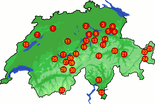
Here's a map of Switzerland showing (roughly) where the hikes are. Click on the numbers, or use the summary below.
For a zoomable guide to all the Swiss hikes, whether half-day strolls or multi-day treks, see the Swiss hike map. This overview is also available as a Google Earth file: ![]() Swiss hikes kmz. It shows the rough location of each of the Swiss hikes, and the accompanying bubbles contain links back to the hike descriptions here at the Activity Workshop. If you haven't got Google Earth installed, you can see the same tracks in GpsPrune instead.
Swiss hikes kmz. It shows the rough location of each of the Swiss hikes, and the accompanying bubbles contain links back to the hike descriptions here at the Activity Workshop. If you haven't got Google Earth installed, you can see the same tracks in GpsPrune instead.
| Name | When | Summary | ||||
1
|
Solothurn | Summer | Medium length, up and over the Weissenstein. Panoramic views and a picturesque chasm on the way back. |
|||
2
|
Uetliberg | All Year | Long walk along the ridge next to Zurich (with shorter options as well). |
|||
3
|
Schnebelhorn | Most of Year | Climb to the highest point in the Zürich canton |
|||
4
|
Ofenloch (new) | Summer | Explore a secret gorge hidden away between Säntis and the Toggenburger hills. |
|||
5
|
Speer | Summer | A circuit walk with views of Glarus, Säntis and the Walensee. Fairly long walk but rewarding panorama from the peak. |
|||
6
|
Churfirsten | Summer | Exploring between the towering Churfirsten and the beautiful Walensee. Medium length walk, but with tiring descent. |
|||
7
|
Chasseral | Most of Year | Spectacular views from the Jura ridge right across to the Berner Oberland |
|||
8
|
Zugerberg | Winter | Easy, circular walk around Zug's local mountain. |
|||
9
|
Einsiedeln | Winter | Fairly flat, scenic loop walk near the Sihlsee. |
|||
10
|
Creux du Van | Summer | An exciting gorge climb, and an incredibly spectacular glacial cirque, near Neuchâtel |
|||
11
|
Napf | Summer | Not too difficult, but fairly long walk over the summit from Romoos to Fankhaus. |
|||
12
|
Rigi | All Year | Easy 3.5 hour walk along the ridge from Scheidegg to Kulm. Panorama of Lake Lucerne, Pilatus, and the surrounding mountains. |
|||
13
|
Mythens | Summer | Easy, but long hike along the very aptly-named Schwyzer Panoramaweg. |
|||
14
|
Klöntal | Most of Year | A loop walk from Glarus out to the Klöntalersee and back. |
|||
15
|
Braunwald | All Year | In Winter, an easy, short walk along the side of the Glarus valley and back, or in Summer a longer hike up and around. |
|||
16
|
Benediktusweg | Summer | Long, difficult hike over two ridges to Engelberg. |
|||
17
|
Habkern to Waldegg | All Year | Easy, short hike with views of the spectacular peaks around Interlaken. |
|||
18
|
Hasliberg-Reuti to Brünig | Winter | Easy but varied walk with views of the Brienzersee and the Wetterhorn, and rail trip over the pass. |
|||
19
|
Disentis | All Year | In Winter, an easy walk along the Senda Sursilvana, or in Summer a higher hike above the Romansch valley |
|||
20
|
Trin to Valendas Sagogn | All Year | Medium difficulty walk along the Rhine "gorge", with intriguing scenery near Flims. |
|||
21
|
Arosa to Lenzerheide | Summer | High, difficult hike from Arosa over the Parpaner Rothorn to Lenzerheide. |
|||
22
|
Scuol valley | Winter | Fairly long walk along the side of the Engadine valley. |
|||
23
|
Val Sinestra | Winter | Exploring a tiny side-valley near Scuol. |
|||
24
|
Munt la Schera | Summer / Autumn | Exploring the Swiss national park around Il Fuorn and the Ofenpass. |
|||
25
|
Diemtigtal | All Year | A loop walk around the side of a valley near Spiez. |
|||
26
|
Schynige Platte to First | Summer | Long, high, difficult hike over the Faulhorn amid incredible scenery. |
|||
27
|
Around Wengen | Summer | A loop walk from Wengen, high above the Lauterbrunnen valley. |
|||
28
|
Under the Eiger | Summer | A long walk exploring Männlichen, Kleine Scheidegg and under the North wall of the Eiger. |
|||
29
|
Lötschental | Summer | Easy walk along the Lötschentaler Höhenweg |
|||
30
|
Aletsch Glacier | Summer | Unbelievable close-up views of Europe's longest glacier, on this relatively easy circuit. |
|||
31
|
Val Verzasca | Summer | From Tenero up the Val Verzasca with stone villages and James Bond's dam |
|||
32
|
Zermatt | Summer | A loop walk from Sunnegga to Riffelalp and back down to Zermatt. |
|||
33
|
Monte San Salvatore | Most of Year | From the lakeside, up and over Monte San Salvatore to Morcote. |
There are more day hikes available by taking single days out of a multi-day hike. Some of those particularly suitable for this include:
| Name | When | Summary |
| Meiringen to Grindelwald | Summer | Long but easy crossing of the Grosse Scheidegg, part of the Alpine Pass Route. |
| Kandersteg to Adelboden | Summer | Tough and strenuous hike over the Bunderchrinde, part of the Alpine Pass Route. |
| Adelboden to Lenk | Summer | Easy pass crossing over the Hahnenmoospass from one valley to the next, part of the Alpine Pass Route. |
| Wildhaus to Amden Arvenbüel | Summer | Long hike along the Churfirstens, day 1 of the Toggenburger Höhenweg. |
| Zürich Rehalp to Meilen | All Year | Easy walk above and alongside lake Zurich, the beginning of the Zürichsee Panoramaweg. |
| Bärenwil to Balsthal | All Year | Open ridgetop walk with plenty of scenery, part of the Jura Höhenweg. |
There's also a brief list of other hikes for further ideas.
Please note that all times and prices are approximate, and may be subject to change since the hikes were researched. Particularly in Winter, the difficulty of a hike depends greatly on the current snow conditions, and can change from week to week. Use common sense and backtrack or shortcut if necessary.
The ![]() icon means that a GPS was used to record the hike, and so waypoints
and 3d plots are available. The
icon means that a GPS was used to record the hike, and so waypoints
and 3d plots are available. The ![]() icon means that photos are available. For certain hikes there are also Kmz files provided, which you can open in Google Earth to show the routes - these are indicated by the
icon means that photos are available. For certain hikes there are also Kmz files provided, which you can open in Google Earth to show the routes - these are indicated by the ![]() icon. These data files can also course can be viewed in GpsPrune if you have that.
icon. These data files can also course can be viewed in GpsPrune if you have that.
Also, please feel free to share your experiences. Any additional information, corrections, suggestions and comments would be gratefully received by email - all due credit will be given.
If you found any of that useful, you may also be interested in trying some Snowboarding in Switzerland as well.