
Hike time: | 5 - 5.5 hours |
Start: | Albisguetli tram stop, Zurich |
Finish: | Sihlbrugg train station |
Season: | All year round |
Profile: | undulating between 700m and 900m, except initial climb from 500m, and final descent to 500m |
Rating: | mostly easy going but long |
Greetings: | "Gruezi", "Gruezi mitenand" |
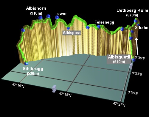
The Uetliberg is not so much a mountain, but more a ridge of hills at around 900m which forms a very large area perfect for hiking and biking, right on the doorstep of Zurich. From Zurich centre (especially near Bürkliplatz and Bellevue), the telecomms mast with its red lights at Uetliberg Kulm is clearly visible, on the green ridge to the West of town. Also visible, Southwards along the ridge, is the squat telecomms tower at Felsenegg, another convenient access point. Actually, Uetliberg Kulm isn't the highest point on the ridge, although it does look that way from Zurich, Kulm is around 850m whereas Albishorn lies at around 910m.
There is a large network of trails in the area, and convenient public transport to both the top and the bottom of the ridge, providing hiking possibilities from an easy hour to 6 or more. The views extend in all directions, showing the Zurichsee curving round towards Rapperswill, the distant snow-capped peaks, the green countryside to the East and of course the spires of Zurich far below.
Free maps of the area are available, showing hiking paths and contour lines, and are excellent. Pick up one of the red leaflets "Ausflugstipps" from Zurich HB, Uetliberg Kulm or Felsenegg cable car station.
The walk described below is a long walk, from Albisguetli to Sihlbrugg. There are many variations you can make on this route, for example using the train to Uetliberg Kulm instead of walking up, or finishing at Sihlwald or Leimbach to make it shorter. For an easy 1.5 hour stroll, get the train to Uetliberg Kulm, follow this route to Felsenegg, get the cable car down to Adliswil and the train back to Zurich from there - this makes a very pleasant half-day round trip.
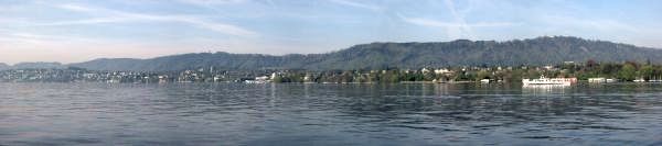 The Uetliberg ridge seen from across the lake 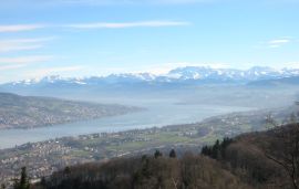 Snow-covered Glarner Alps beyond the Zürichsee 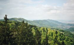 Looking back along the ridge towards Kulm |
For a zoomable, scrollable map of this hike, see this online map using Openstreetmap or Opencyclemap.
You can also download this kmz file uetliberg.kmz (4 kb) to open it in programs like Google Earth or GpsPrune and then transfer the track to your GPS.
For the walk as described, you can take the number 13 tram from Zurich HB to Albisguetli to start the hike. The return is a direct S-bahn from Sihlbrugg back to Zurich HB. In this case it's slightly cheaper to get single tickets (CHF 2.60 + CHF 3.60 with halbtax) rather than a day card (CHF 7.20 with halb-tax), but the day card will give you 24 hours transport round the city as well, so could well be worth the extra. Obviously if you have already bought a city centre ticket (or already have a city pass), then you just need a single extension ticket (CHF 2.60 with halb-tax) for the return journey.
If you'd rather ride up to Kulm than walk, you can take the S-bahn (S10) from Zurich Hauptbahnhof (at least every half-hour from platform 1 or 2 downstairs) to Uetliberg. Another popular access point is Felsenegg, which is reached by cable car from Adliswil (cable car covered by the normal tram / bus / boat / train ticket if you get the appropriate zones).
On 7 March 2005, the walk from Kulm towards Felsenegg is open, but very very little else is. The cable car at Felsenegg is closed, the restaurant at Felsenegg is closed, the resturant Gmuetliberg is closed, the restaurant Uto Staffel is closed, even the tiny Teehütte near the lookout point is closed. Seems like the only thing open is the posh restaurant at the very top of Kulm, which is a shame because the footpath is beautifully prepared, the snow is hanging off the trees and the skies are blue and sunny.
Albisguetli - Uetliberg Kulm - Felsenegg - Buchenegg - Albispass - Albishorn - Sihlbrugg bahnhof
 |
going Southeast from right to left |
From the end of the number 13 tram line, follow the road uphill towards the telecomms tower, until the road bends sharply right. Keep on the track round to the left, and at the fork, follow the signpost for the "Fohreneggweg" to the left. The path climbs, crosses another track (Jucheggstrasse), and then begins a set of hairpins to climb the steep slope. Inbetween the trees you can soon gain views of the lake and beyond (on a clear day!). This is the steepest section of the hike, and has occasional stepped portions. Respite comes after 20 minutes with a lookout point, from which open views of the lake (and a few breaths) can be had.
5 minutes up from here, you reach the ridgetop and the first views to the East. Here a set of signs show the many possible routes, and a wider, flatter path runs along the ridgetop. From here an optional side-trip follows this path up to Kulm and returns to continue the trail South.
The summit of Kulm requires more ascent, but the views seemingly straight down to the spires of Zurich and out in all directions are ample reward. The free metal lookout tower provides even more altitude, and the panorama board gets you oriented with the ridge, the lake, Rigi and even further afield to Titlis etc. For this side-trip, follow the signs to "Kulm" uphill past the "Uto Staffel" restaurant (recommended). A little further on there is a choice between (lots of) steep steps or a longer, more gentle path around the summit. This takes about 10-15 minutes each way, returning to where you joined the ridgetop.
If you have taken the S-bahn to Kulm, follow the signs for the "Planetenweg" to join this route on the ridgetop after 10 minutes. Again, a detour to the summit on the way is recommended.
From the ridgetop, the path climbs gently Southwards and undulates gently for 15 minutes to a lookout point where the lake views open out. From here there's a signposted track to a tiny "Teehütte" providing warming tea and an incomparable cosy isolation.
After leaving the woods to pass through open farmland, a narrower footpath leaves the quiet vehicle track to climb up to the left. Follow this, and the signposts to the Felsenegg cable car (LAF) to bring you past the squat telecomms tower and to the cable car station after about 40 minutes.
To return to Zurich from here, you can take this cable car (but you may want to check out the nearby restaurant first - see below). The cable car runs every 15 mins down to Adliswil, carrying 15 people. From the lower cable car station, walk to the road on your right, and you'll see signs directing you to Adliswil bahnhof. It's about a 5 minute walk, clearly signed, to the station from which there are regular S-bahns back to Zurich.
There's another good restaurant (imaginatively called Restaurant Felsenegg) a few minutes walk further on past the cable car station. Continuing beyond here, at the signpost (at 790m), follow the path towards "Albispass". After about 15 minutes, you come to the small settlement of Buchenegg. After the isolation of the ridgetop, it seems strange to have to cross a road, but the signs lead you past Restaurants Buchenegg and Näfenhaus, and on still signposted "Albispass". But the traffic is soon left behind once again, as the way meanders past sheep fields and up along the flank of the ridge.
35 minutes further on, as you emerge from the forest, you briefly glimpse the shimmering Zugersee to the right, with Rigi beyond, and then start to descend into Albispass, another small village at 790m. Again there are several possibilities for refreshments here.
From Albispass, there are hourly buses to Langnau (at half-past the hour), providing an opportunity to cut the walk short if desired. There is also the possibility of diverting down to the Türlersee, see the alternatives below.
20 minutes further on brings you to the lookout tower at Hochwacht, which is surprisingly high and well worth a climb. This gives excellent views back along the ridge to Kulm, and forward to the Zurichsee and Zugersee, and shows just how far you've already walked. The terrain around here is a little more demanding than the gentle slopes earlier, but still not too difficult.
Now the path starts to climb a bit more seriously, and after 35 minutes you reach a shelter at restaurant Albishorn, and a panorama board showing the now much closer views of Rigi, the Vierwaldstättersee, Pilatus and the peaks to the South. A little further on, the path splits and gives the option of a signposted "Aussichtsweg" (scenic way), which follows the edge of the forest before the paths merge again. This Aussichtsweg provides some of the best views on this walk (when the weather allows) with sweeping views towards Rigi and Pilatus. Some 35 minutes beyond Albishorn, the path starts to descend, and the signs to "Sihlbrugg station" (note - quite a long way from Sihlbrugg Dorf!) lead around to the left and down through the woods towards the noisy road. The "längerer treppen abschnitt" route involves many steps straight down the hill, whereas the other way is slightly longer but gentler. Both lead through the lush, fragrant woods and meet after about half an hour at Sihlbrugg station.
S-bahns back to Zurich leave from here approximately every half hour. Note that platform 1 isn't signposted - it's the bit of track in front of the car park, where with a bit of luck there may be a red Sihltalbahn train waiting.
The following are the coordinates for waypoints along this route, obtained from GPS. They can be used either in another GPS, or along with a map, to provide additional references if necessary.
                   Latitude       Longitude       Altitude (m)
Albisguetli Tram   N 47°21.132'   E008°30.425'      507
Viewpoint          N 47°20.783'   E008°30.065'      709
Ridgetop           N 47°20.787'   E008°29.786'      761
Uetliberg Kulm     N 47°20.958'   E008°29.489'      854
S-bahn Uetliberg   N 47°21.124'   E008°29.239'      820
Lookout            N 47°20.172'   E008°30.120'      788
Felsenegg          N 47°18.603'   E008°30.457'      800
Buchenegg          N 47°17.820'   E008°30.474'      786
Albispass          N 47°16.554'   E008°31.295'      791
Tower              N 47°15.981'   E008°31.915'      901
Burglenstutz       N 47°15.470'   E008°32.245'      915
Albishorn          N 47°15.037'   E008°32.681'      909
Mattli             N 47°14.076'   E008°33.785'      819
Sihlbrugg Stn      N 47°14.299'   E008°34.611'      529
Find the red "Ausflugstipps" leaflet as mentioned earlier, and check out the map of the Zurich area produced by Rough Guides.
Also note that the Uetliberg has a signposted sledge run when there's sufficient snow, offering a 3km Schlittelweg from Kulm down to Triemli. Then you can simply take the S-bahn back up to the top again for another go. Beware, this is very popular, and collisions on busy evenings are not uncommon! Cushions and lights are optional (but useful) accessories.
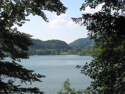
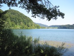
The Türlersee
The Türlersee
An alternative to continuing along the Uetliberg ridge is to take a diversion down to the beautiful Türlersee.
As described by myswitzerland.com,
there are a couple of signposted paths leading down from Albispass, and the nature reserve surrounding this gem of a lake
adds variety to the ridgetop hike. From Türlen (N 47°16'03.7, E008°30'43.6, 657m), you can get the
bus back to Zürich with a 2-zone extension ticket.
From Albispass, there are two paths down, both of which initially follow the road curving down to the Southwest. The direct route is then signposted to the Türlersee, but by taking the right-hand path through Chnübrechi and Haberssaat to the Northwest corner of the lake, you can then follow the pleasant Rundweg round the Southern side of the lake (with the lake on your left) to loop round to the bus stop at Türlen. There is a popular Strandbad here for swimming, and an adjacent camping ground. The buses run approximately hourly from "Türlen, Türlersee" (zone 51 of the Zürich network) to Triemli.
Another alternative tour, together with map and photos, can be found at romankoch.ch. Also, since August 2005, a new 2- or 3-day Panoramaweg has been opened on the opposite side of the lake between Zürich Rehalp and Feldbach. For more information see the Zürichsee Panoramaweg page in the multi-day hikes section.