
Hike time: | 4.5 to 5 hours |
Approx dist: | 16 km |
Start: | La Combaz |
Finish: | Sainte Croix |
Profile: | Between 1070m and 1610m, |
Rating: | Easy |
Greetings: | Bonjour |
This page describes the twelfth day of the Jura ridgeway walk, from La Combaz over the Chasseron to Sainte Croix. The Chasseron, at 1610m, is the highest point of the ridgeway so far and offers an exhilarating ridgetop path with plenty of views.
To get to the start of the day's hike at La Combaz, there are buses from Couvet, which lies on the same train line as Noiraigue from Neuchâtel. A short distance before La Combaz is another bus stop called Les Rochats which is however quite a long way from the restaurant with the same name. Unfortunately these buses are very irregular even when they are running, so in other cases the nearest option is the train station at Môtiers which requires a climb through the Poëta Raisse (see the Creux du Van hike) to get up to La Combaz. From the end of the walk at Sainte Croix there are trains to Yverdon-les-Bains with plenty of long-distance connections.
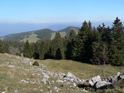 Looking back from the ascent of le Chasseron 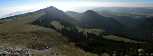 Panorama on the ridgetop of Le Chasseron 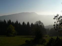 View from the descent 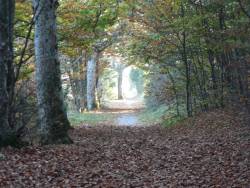 Leafy track towards Sainte Croix |
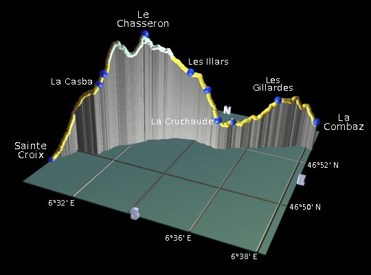 |
La Combaz - Les Gillardes - La Cruchaude - Les Illars - Le Chasseron - Les Avattes - Les Praises - Sainte Croix
Firstly a note about the signposting. As with other places on this route, the useful red triangles on the yellow signposts have been painted over in yellow, making them difficult (but not impossible) to see. Apparently they're being replaced with the green "route 5" signs, but some genius decided to obscure the old markings before installing the new ones. In any case, it's worth using both signposts as a guide and looking carefully for the yellow triangles.
From the bus stop at La Combaz, follow the signpost to the right leading up behind the restaurant. The path climbs the grassy slope and curves leftwards into the trees. There follows an extremely muddy section on a track carved up by heavy vehicles, leading to a track junction. Turn left here, following the track up through the trees.
Emerging from the wood, continue ahead along a corridor of grassy fields. Keep left of the farmhouse and pass the signpost at Les Gillardes by the fence. Continue ahead on the narrow road downhill, signposted for La Calame and Le Chasseron. Shortly a pair of peaks comes into view ahead, a sharp triangular peak to the left with a tower on it and a flatter, broader one to the right. Le Chasseron is the one on the right, with the route following the ridge past the triangular peak afterwards.
Follow the narrow road downhill, turning left at the junction to continue the descent. A signposted track heads right leading to idyllic farmland, with grazing cows surrounded by wooded hills. Pass the signpost at La Calame, heading to the right of the farmhouse towards La Cruchaude. Here, don't go straight ahead towards Sainte Croix but fork right uphill towards Le Chasseron (not quite as sharp right as the signpost suggests).
Climb up the steep path to Les Cernets-Dessous, and continue the ascent ahead. The gradient of the path shortly eases, taking a grassy track across the fields to the signpost at Les Illars. Here it joins a small road, climbing steadily before becoming a steep path towards the summit. Suddenly you emerge on the grassy top section, with hazy views to the left and right and the main summit just directly ahead. The by-now-familiar peaks of the Berner Oberland are stretched out on the southerly horizon, and to the north the French border and rippled hills.
Having climbed the last part of the ascent, you reach the trig point and the windy ridgetop. The tilted ridge drops surprisingly sharply down to the right, but the panoramas from this vantage point are almost 360 degrees. There's a hotel just down to the left with a panorama board identifying the mountains. The triangular peak seen earlier is now directly ahead.
From the hotel, follow the track past the dishes and masts, and take the steep path down to follow the ridgetop. This superb exposed stretch gives spectacular views, climbing back up over the second peak with its small mast. Continue along the path to Les Avattes, where there is another restaurant. As you descend, a second ridge rises to the left, blocking the southerly views. Our path will cross over to join this ridge on its way to Le Suchet.
From Les Avattes, head downhill to the left, crossing the fence using the gate by the tree, and descend past La Casba (don't forget to rock it on your way past). Now either take the track to the left, or take the path straight ahead marked with faint red/yellow paint on the rocks. This meets the track again anyway quite shortly, and the track curves round to the right towards Les Praises. As this track passes a field of cows and horses, a very faintly marked path takes a shortcut across the field to the Les Praises signpost - if you miss that, just continue on the track to the junction and turn sharp left.
From here it's just a short walk straight ahead on the track to Sainte Croix, past the church to the main street. The train station is clearly signposted, more or less directly ahead.
The following are the coordinates for waypoints along this route, obtained from GPS. They can be used either in another GPS, or along with a map, to provide additional references if necessary.
                          Latitude       Longitude      Altitude(m)
     La Combaz           N 46°52'33.3    E006°38'14.6    1223
     Les Gillardes       N 46°52'15.5    E006°36'49.1    1322
     La Calame           N 46°51'42.7    E006°35'24.7    1210
     La Cruchaude        N 46°51'29.9    E006°34'57.8    1223
     Cernets-Dessous     N 46°51'37.1    E006°34'25.5    1357
     Les Illars          N 46°51'38.7    E006°33'43.5    1427
     Le Chasseron        N 46°51'06.4    E006°32'17.7    1608
     Les Avattes         N 46°50'11.0    E006°31'25.6    1458
     La Casba            N 46°50'05.9    E006°31'18.3    1412
     Les Praises         N 46°49'54.2    E006°30'25.5    1255
     Sainte Croix        N 46°49'10.2    E006°30'04.1    1066
To view this hike in Google Earth or Google Maps, see the Kmz file for the whole Jura Ridgeway on the main page.
This day's walk (including an extra climb up from Môtiers) is briefly described at myswitzerland.com (archived).
The next section on this hike will continue over Le Suchet to Ballaigues.