
 |
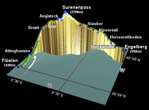
This is the fourth stage of the Alpine Pass Route. As mentioned in the previous section (Linthal to Flüelen), Altdorf is a more common starting point than Flüelen, but our Höhenweg took us just a bit further South. This stage is described here as a two-day hike, with an overnight in Brüsti. Although the first day is quite short, it does require quite a climb, and trying to do both sections in a single day would be quite tiring. It can easily be reduced to a one-day hike though, simply by taking the bus across the valley floor to Attinghausen and then using the cable car up to Brüsti. In fact, this is what most people seem to do, apart from those stubborn types who insist on walking the whole way.
The second day, from Brüsti up to the pass and down the other side, is highly recommended and full of contrast. Initially looking back towards the Vierwaldstättersee and the valley leading up to the Klausenpass, the views are spectacular, and from the tranquil pass itself you can see ahead to the massive Titlis. The final stretch into Engelberg leads along the base of an awesome, narrow valley with numerous spectacular waterfalls and peaks overhead.
Flüelen is a stop on the main North-South line, with very frequent trains through Schwyz and Arth-Goldau to Zürich, and through Göschenen and Bellinzona to Chiasso. Engelberg is at the Southern end of the Luzern-Stans-Engelberg line, with hourly trains down the valley to Luzern, from which there are many connections.
From Zürich, there are frequent direct trains to Flüelen in about 1h15 (CHF 11 one-way with halbtax). Coming back from Engelberg, you need to change in Luzern, taking around 2h10 (CHF 17 one-way with halbtax).
For accommodation at Flüelen, Altdorf or Attinghausen, see the searchable list of accommodation at i-uri.ch, or the list at attinghausen.ch. For staying in Attinghausen I have heard good reports of the Restaurant Krone near the lower cable car station. If you do decide to walk up rather than take the cable car, one conveniently-located place to stay is the Berggasthaus Brüsti, right next door to the upper cable car station. Unfortunately, I found it to be a highly unpleasant place to stay, with extremely hostile and offensive hosts. Also there are no showers, and they refuse to allow people to stay in the dorm (only the overpriced rooms). Those who wish to avoid such an experience may want to carry on a few minutes up to the seemingly much friendlier Gasthaus z'Graggen instead, which offers dorms for CHF 25 or rooms from CHF 65, and manages to provide showers too.
For Engelberg, try engelberg.ch, or the youth hostel.
Flüelen - Attinghausen - Brüsti - Angistock - Surenenpass - Blackenalp - Stäuber - Stäfeli - Alpenrösli - Engelberg
Hike time: | 4 hours |
Approx dist: | 10 km |
Start: | Flüelen station |
Finish: | Brüsti |
Profile: | from 430m up to 1520m |
Rating: | easy to medium |
The start of this day's stage is the railway station at Flüelen, on the shores of the Vierwaldstättersee. The sun brings out the vivid turquoise colour of the waters, making quite a spot to take a breather before starting the walking. Today's walk is only a relatively short one though, so you can afford to take your time to appreciate it.
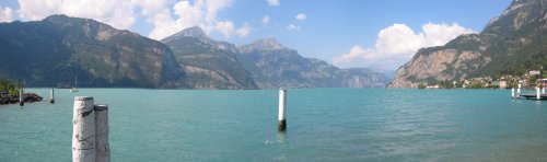
The magical colour of the Vierwaldstättersee by Flüelen
From the lakeshore, head Southwards with the railway line on your left, following the signs for the "Weg der Schweiz"
towards Attinghausen. Bear right through a fairly industrial area to reach the open, quiet lanes between the railway and
the river. A so-called "Hochwasserschutzlehrpfad" then leads to the river Reuss with the busy motorway alongside.
I expected the motorway and power lines to give a bleak stretch to the walk, but I found the wide open valley
quite pleasant, perhaps because it was a rare flat stretch, and it was interesting to look up to the left to spot
the previous day's route.
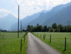
The lane leading away from Flüelen
On the opposite side of the river from the motorway, on the right-hand-side as you head upstream, the cycle track and footpath follows a raised embankment (Hochwasserschutz = flood protection) and cuts swiftly across the flat valley floor. After around 1h10 from Flüelen you reach Attinghausen Brücke, where you turn right signposted to the Brüsti Seilbahn. The cable-car cables leading up to Brüsti can easily be seen from here.
Follow the road uphill for a few minutes to reach the (unmanned) lower cable car station, from which you can
invest CHF 10 and a few button pushes to be whisked up over 1000m all the way to Brüsti. On the other hand,
if you haven't had enough walking yet today (or you're one of those types who are refusing to take such assistance
on the APR), there is a signposted footpath leading up to the right of the cables.
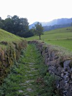
Walled path climbing up towards Brüsti
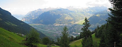
View from climb up to Brüsti, with lake on left and Klausenpass top-right
The middle cable car station is not much further up, and then the rocky path leads steeply uphill on the left, often passing between stone walls. It is quite a long climb up (over 1000m, as already noted), but the views back down to the valley, across to the lake by Flüelen and back along the valley to the Klausenpass keep the spirits up. In particular, you get great views of the previous day's Höhenweg over the shoulder of the hill. And somewhere over there is Linthal, and beyond that the Richetlipass, and ...
After around 2h30 of steady, occasionally fairly steep, climbing, the path levels out somewhat at
Höchiberg, where you should bear right for Brüsti. Brüsti itself is just another 15 minutes'
walk round the corner, where you'll find the upper cable car station and the awful Berggasthaus. If you're
planning to stay overnight here, continue on uphill (signposted for the Surenenpass) for another 10 minutes
to the Berggasthaus z'Graggen.
Hike time: | 7.5 hours |
Approx dist: | 21 km |
Start: | Brüsti |
Finish: | Engelberg station |
Profile: | from 1520m up to 2290m and back down to 990m |
Rating: | medium |
If you're coming up by cable car to start the day's walk from Brüsti, head right out of the cable car station and follow the signs for the Surenenpass. As always (so far), it's quite difficult to go wrong with the navigation on these major pass crossings. The easy path climbs steadily up towards Grat, with just a short section requiring a bit of care. On this section steps and handrails provide reassurance.
As you pass through Grat, reached in around 45 minutes from Brüsti, there are plenty of views around
the ridge, and back down to the Vierwaldstättersee etc, and you can see the pass ahead for the first
time.
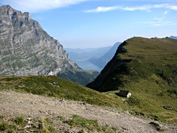
Looking down to the Vierwaldstättersee
Looking back down the ridge near Grat
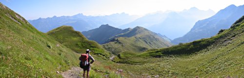
Two hikers on their way up to the pass
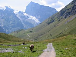
The path onwards is stony but easy as it climbs steadily up to Angistock in around an hour, from where you get a very clear view of the scree-laden slopes ahead and the pass above.
From Angistock, there are two paths leading up to the pass, with the paint markings strongly recommending the lower route (Unterer Weg) dropping to Langschnee. However it wasn't clear why the upper route to the right was disfavoured, as it was shorter, involved less up and down, and presented no problems to those who went that way. In snowier times it's possible that the scree on the upper path may be more difficult, but in August in a heatwave it was actually easier up that way than crossing the remaining snow at Langschnee.
Either way, the path crosses some scree and ends with a steep zigzag up to the summit, around 50 minutes
from Angistock.
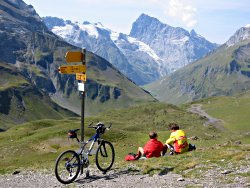
Cyclists admiring Titlis from the pass
As expected, the views from the top are spectacular, both back down the Brüsti side (as before) and now suddenly forwards as well, looking across at the awesome Titlis. The incongruity of this massive, sheer-sided block of rock makes it look even more enormous. The pass itself is quiet and grassy, an ideal spot for a satisfying break.
When ready to continue the journey, follow the path steeply down to the left past a Schutzhütte
(note: this tiny unmanned hut is spotless, but not ideal for an overnight stay except in emergency)
and then along a clear path down towards Titlis. Shortly the path reaches a pasture underneath a towering
bowl of cliffs, reaching Blackenalp after around 45 minutes. In this idyllic spot, there is a popular
restaurant which also offers overnight dorm accommodation from CHF 20 and sells freshly-made cheese
too.
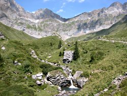
Stream running down from bowl of Blackenalp
Big Titlis, tiny cows
Pass the tiny, rather gloomy chapel, and bear left to cross the stream. The broad track then curves round to reach Stäuber after around half an hour. Just over to the left here is an excellent picnic spot, on a rocky outcrop by a waterfall.
Now, Stäuber is where you have to make a route decision, using the panoramic picture helpfully provided.
The choice is basically between a higher, flatter route followed by a cable car descent, or a more gradual descent
alongside the river. I'm told the views along the upper route are great, either to Äbnet and its cable car
down to Stäfeli, or all the way to Fürenalp with its cable car down to near Herrenrütiboden.
But on the other hand, stubborn non-cable-car-users will have to take the valley route, (which also gives great
views, by the way).
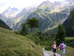
Walkers admiring the valley down to Engelberg
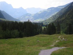
Gentle descent down to Engelberg
So, taking the valley route, you pass beneath towering cliffs and jagged peaks, with numerous waterfalls, shortly passing Stäfeli with its restaurant and small cable car station. Continue along the track, and take the path to the right, which follows the track a bit higher up, and then rejoins it at Alpenrösli (with another restaurant) after around an hour.
A path then leaves the track to the left, emerging by a car park. Shortly after the car park, another unsigned path leaves to the left between the picnic benches, following alongside the stream, until a track leads up to meet the road at Herrenrüti, after 40 minutes. Note that the blue "Alpine Route" signs have nothing to do with the Alpine Pass Route (confusingly), so keep following the Engelberg signs. The town itself is visible from here anyway as the valley curves around.
Follow the grassy path, gently descending towards Engelberg, and pass the paraglider landing area to
reach Herrenrütiboden in about 30 minutes.
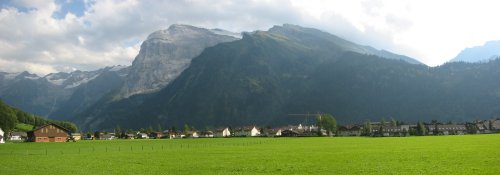
View from near Engelberg, with Surenenpass over to left, Titlis middle-left and the Jochpass to the right
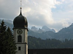
Spire of Kloster, with Jochpass beyond
Continue past the lower cable car station from Fürenalp (from which you can take a shuttle bus to Engelberg if you wish), and follow the "Wasserfall" signs onward. The path leaves to the right of the road, and somewhere or other must pass a waterfall of some kind (although I never did find it). Pass through Vorder Stalden and Holzkapelle to the outskirts of Engelberg, following the signs for the easily-visible Kloster. From this grassy plain it is impossible not to peer up towards the Jochpass to anticipate the next stage of the route. A mixture of roads and paths lead you diagonally away from the main road, through the Kloster's graveyard and down to the main entrance of the Kloster in around 1h15.
After an obligatory visit inside the grand cathedral, follow the main pedestrianised street through the centre of
Engelberg, where you will find the station on your left after 5-10 minutes. Now you can get ready for the following
section on the route, surmounting the Jochpass over to Meiringen.
The following are the coordinates for waypoints along this route, obtained from GPS. They can be used either in another GPS, or along with a map, to provide additional references if necessary.
                           Latitude       Longitude    Altitude(m)
       Flüelen            N 46°54'06.8    E008°37'27.0     432
       Attinghausenbrücke N 46°51'48.6    E008°37'57.2     452
       Cable car base     N 46°51'40.6    E008°37'44.0     486
       Höchiberg          N 46°50'27.8    E008°36'31.8    1430
       Brüsti             N 46°50'35.2    E008°36'24.3    1525
       z'Graggen          N 46°50'37.6    E008°36'07.6    1585
       Grat               N 46°50'42.5    E008°35'10.4    1820
       Water              N 46°50'37.4    E008°34'17.8    1905
       Angistock          N 46°50'32.7    E008°33'37.7    2031
       Langenschnee       N 46°50'22.3    E008°33'17.1    2004
       Surenenpass        N 46°50'11.3    E008°32'44.3    2291
       Schutzhütte        N 46°50'05.3    E008°32'46.9    2265
       Blackenalp         N 46°49'32.5    E008°30'54.2    1773
       Chapel             N 46°49'30.3    E008°30'48.1    1787
       Stäuber            N 46°48'51.1    E008°30'11.6    1630
       Stäfeli            N 46°48'01.6    E008°29'40.1    1393
       Alpenrösli         N 46°47'42.2    E008°28'58.5    1258
       Herrenrüti         N 46°47'44.0    E008°27'38.8    1165
       Herrenrütiboden    N 46°48'04.8    E008°27'02.9    1084
       Vorder Stalden     N 46°48'28.8    E008°26'25.4    1050
       Holzkapelle        N 46°49'03.9    E008°25'36.7    1030
       Engelberg Kloster  N 46°49'14.8    E008°24'33.3    1011
       Engelberg Station  N 46°49'11.2    E008°24'10.3     994
Try attinghausen.ch or engelberg.ch. Or for the Fürenalp cable car, see (not surprisingly) fuerenalp.ch. Local information can be found at urionline.ch or lakeluzern.ch.