
 |
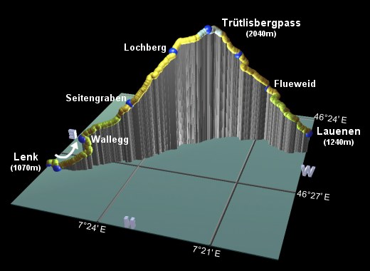
This is the twelfth stage of the Alpine Pass Route, crossing from Lenk over the Trütlisbergpass to Lauenen (sometimes the pass is signposted as the Trüttlisbergpass). This is a reasonably short trip from one valley to the next but with a reasonable amount of climbing and descending. Because the next stage after this one (the Krinnenpass) is particularly short, it can be combined with this pass in a single day, although quite a long one.
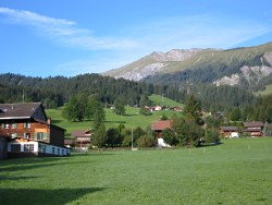
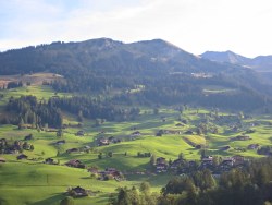
Both Lenk and Lauenen are quiet, typical Swiss villages, and on this walk you also get great valley views on both sides of the pass, and a short trip up a gorge to add some excitement.
Lenk has rail links to Zweisimmen, which in turn has links to Spiez. To get back from Lauenen, you would need to take the bus to Gstaad which has connecting train services to Montreux and Zweisimmen. The last bus from Lauenen is currently just before 7pm.
From Zürich to Lenk, you need to get the train through Bern and Spiez to Zweisimmen, and then the bus from there - the total journey takes just over 3h and CHF 35. Getting back from Lauenen would involve the bus to Gstaad and then trains to Zweisimmen, Spiez and Bern - total time between 3h40 and 4 hours, costing around CHF 38 (with a half-price card). As a day trip it would be cheaper to get a day card rather than a round-trip ticket.
For Lenk see the list at lenk.ch. A few minutes' walk out of the centre of Lenk is the Ökohof Schönegrund, which is recommended for good value rooms and a very friendly welcome. For Lauenen see gstaad.ch.
Lenk - Trütlisbergpass - Lauenen
Hike time: | 4.5 to 5 hours |
Approx dist: | 15 km |
Start: | Lenk station |
Finish: | Lauenen bus station |
Profile: | from 1070m up to 2050m and down to 1240m |
Rating: | easy-medium |
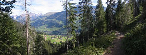
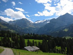
From the centre of Lenk you can see the v-shaped valley leading up to the Trütlisbergpass - the typically impeccable signposts lead from the station Westwards through the village and turn right along Aegertenstrasse (just past the bakery that's open on Sunday!!).
A short way along Aegertenstrasse, you reach a bridge at Wallbachbrücke, where the signposts lead left up a path alongside the stream
(the Ökohof Schönegrund is a short distance further on this road on the right). The early morning sunshine brings out the contours of
the grassy side of the valley opposite, an idyllic picture. Where this path forks, take the right-hand option,
along a track still beside the stream, up towards the Wallbachschlucht.
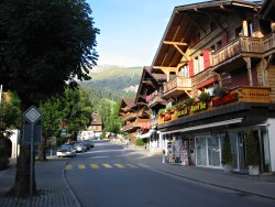
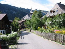
Lenk centre
View towards the Trütlisbergpass
Sunlight on the grassy slopes of Lenk
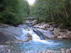
Bridge over the Wallbach stream
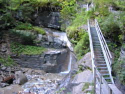
Ladder up into the gorge
Continue upstream on this track to reach the gorge, where metal stepladders, handrails and chains make the way easier. The continual force of the water has carved out impressive bowls, chutes and pools from the rock here. The path, rocky in places, climbs steeply up alongside the falls, with winding sets of steps, and continues on between the trees.
After around 45 minutes from Lenk, the path emerges from the trees by the chairlift cables not far from the Restaurant/Berghaus Wallegg,
which has good views out over the valley from its prominent position.
Looking back towards Lenk
Restaurant Wallegg with a view
Track through the forest
From the restaurant, the path heads up beside the edge of the wood, following the chairlift cables straight uphill. As it curves around with views back over the valley, it follows the Luchsweg, with information boards about lynxes and the other wildlife of the area.
When the Luchsweg splits to the left, continue to follow the Trütlisberg signposts, rejoining the stream and then following a track
up to Seitengraben, reached after around 45 minutes from Wallegg.
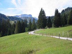
Track winding up towards the pass
Pass in sight
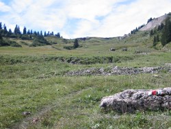
At Seitengraben a path leads rightwards uphill, climbing steadily and marked with red and white paint splashes on the rocks. Some of this stretch can get very boggy, even without much recent rain. As the pass comes eventually into view, the path itself becomes very faint - at one point it virtually disappears as it goes straight up alongside a barbed wire fence, before cutting left across a small stream (with slippery slate), reappearing as a worn path across the grass.
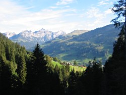
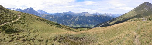
With spectacular panoramas to the left (rolling grassy slopes, stark rocky formations and snow-covered peaks towering beyond), the
path continues to climb, before levelling out towards the top and winding gently up to the unassuming pass.
Panoramic views from the route to the pass
View from pass towards Lauenen
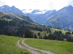
Descent towards Lauenen
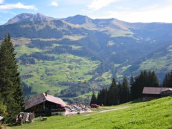
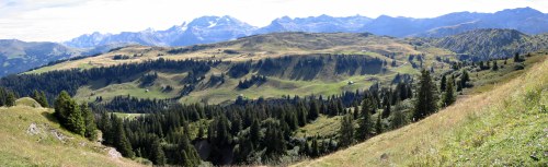
Trütlisbergpass itself, reached after around 1h30 from Seitengraben, is broad and indistinct, and covered with tufty grass and heather, but provides excellent panoramic views in all directions, with some intriguing eroded rock formations and countless peaks as far as the eye can see. Ahead in the bottom of the valley lies Lauenen, towards which the path weaves lazily around the corner.
As the path drops, sometimes steeply, through the clumpy grass and flowers, you can see ahead to the next pass on this route, the
Krinnenpass, which from here looks rather low and even covered with trees(!). A bit different from the high, barren passes just a few days
ago! Ater around half an hour, you reach Vordere Trütlisberg.
View past Lauenen to the Krinnenpass
A hard day in the mountains
Road dropping to Lauenen
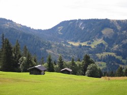
Busy bustling Lauenen
Continuing to descend steadily from Vordere Trütlisberg, the route follows a mixture of paths and tracks for around 25 minutes down to Flueweid, where it meets a paved road.
From here, a mixture of roads, tracks and paths wind steadily down towards Lauenen, with spectacular views of the high peaks to the left, and the lush green valley around. After around 45 minutes, you emerge in the centre of the village directly by the post bus stop. From here, buses leave irregularly and infrequently to Gstaad, with the last one currently leaving just before 7pm.
For the next stage of the Alpine Pass Route over the Krinnenpass, see Lauenen to Gsteig.
The following are the coordinates for waypoints along this route, obtained from GPS. They can be used either in another GPS, or along with a map, to provide additional references if necessary.
                           Latitude       Longitude    Altitude(m)
       Lenk station       N 46°27'28.0    E007°26'37.8    1068
       Wallbach Brücke    N 46°27'36.0    E007°26'15.6    1087
       Rest Wallegg       N 46°27'18.2    E007°25'31.2    1324
       Seitengraben       N 46°26'45.9    E007°24'16.2    1570
       Lochberg           N 46°26'03.6    E007°23'17.0    1910
       Trütlisbergpass    N 46°25'33.1    E007°22'28.1    2038
       Vord. Trütlisberg  N 46°25'14.4    E007°21'39.0    1818
       Flueweid           N 46°25'08.6    E007°20'46.7    1540
       Lauenen bus stop   N 46°25'26.6    E007°19'21.3    1241
For local information, see adelboden.ch, including a map of the Frutigen area. The panorama at skigstaad.ch shows a broad overview of this pass and the neighbouring ones, and lenk.ch has a much clearer panorama (700k pdf) showing the route either side of Lenk, from the Hahnenmoospass to the Trütlisbergpass. It also has a pair of good town maps.