
Hike time: | 2.5 hours |
Start: | Habkern post bus |
Finish: | Waldegg / Beatenberg post bus |
Season: | Winter |
Profile: | from 1050m to 1400m, then down to 1200m |
Rating: | short, easy Winter walk |
Travelling from Bern to Interlaken along the shore of the Thunersee, after passing the pyramidal Niesen on the right hand side, you can spot the Rigi-like form of the Niederhorn on the far side of the lake, just before Interlaken. This walk takes you over the 'shoulder' of this mountain, giving unparalleled vistas of the Eiger, Mönch and Jungfrau, with the Niesen ahead and Interlaken and the Thunersee far below. It's an easy afternoon's walk.
As well as Winter walking, this is also a popular spot for paragliding, and you may well see many pilots gliding back down to Interlaken if the conditions are suitable.
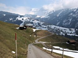 Looking back to Habkern 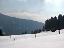 The snowy path with the three Bernese giants behind 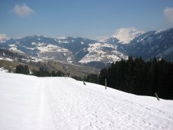 The path away from Habkern 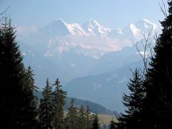 Looking across to the Eiger, Mönch and Jungfrau, above the Interlaken valley 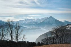 The characteristic shape of the Niesen and the ridge behind |
The start of this walk at Habkern Post is reached by an hourly post bus from Interlaken West train station. The bus winds its way up the side of the Harder ridge for around 15 minutes, for around CHF 3. Hourly post buses also bring you back from the end of the walk, at Waldegg or Beatenberg, to Interlaken West in around the same time.
From Zurich you can get to Interlaken West either via Bern (quicker, sometimes direct but slightly more expensive) or via Luzern (over the Brünig pass). Or even go one way and return the other. The return ticket via Bern is CHF 54 with halbtax, and then you can get the other tickets from the bus drivers.
Habkern - Hellboden - Bühlbach - Amisbüel - Waldegg
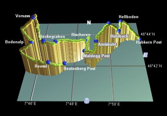 |
From the bus stop at Habkern Post, go up a short way to the post office, and follow the steep steps up the right hand side to meet the road at the top. Here, follow the signpost for the "Winterwanderweg" leading uphill to the left. The route continues up the hillside, still signposted "Winterwanderweg" and "Waldegg". As you head back towards the Thunersee, you cross a bridge at around 30-40 minutes.
Continue uphill through the trees to reach Hellboden, before dropping down to Bühlbach after around half an hour.
At Bühlbach, turn right, still signposted Beatenberg / Waldegg, and resume the climb once more. Gradually the icy Bernese giants slide into view from behind the Harder ridge. Follow the signpost to the left, up a snowy path, and follow the yellow painted signs up between the farm buildings. Shortly you meet a broad track, going up to the left, and the scenery keeps on improving, reward for the effort of the climb! Eventually the majestic trio of the Eiger, Mönch and Jungfrau reveal themselves as the path climbs up through the trees to meet a broad track after around 40 minutes.
This is the highest point of the walk, unless you want to take the rightward route round to the top of the Niederhorn, so from here the track descends gently to the left, still signposted Waldegg, with the incredible panorama laid out to your left. From Schynige Platte and the Faulhorn ridge, past the Jungfrau giants, and right across to the Stockhorn and beyond, this is the most scenic stretch, and definitely the most popular. The signs lead onward to reach Amisbüel after around 30 minutes.
Continuing towards Waldegg, you soon pass a take-off point for paragliders and hang-gliders, on a steep grassy slope overlooking the scenic valley. Lower down the path splits, either way passes down between houses to reach Waldegg post bus stop at the road junction after around 25 minutes. There are a few good options for refreshments here before taking the post bus back to Interlaken.
For those still with energy (or as an alternative walk), there is another path starting from Waldegg and going via Rischeren across to Bodenalp to the West. This is also signposted as the "Höhenweg" and although it passes largely through thick forest, the intermittent views out over the valley, lakes and peaks make it worth the climbing. Being quite shady, the snow can last longer on the path here, and on the stretch down from Bodenalp towards Roossi it is also used as a sledge run. Finally, the walk descends to Beatenberg to the post bus stop.
From Waldegg, following the signs for Rischeren and Höhenweg, the cleared path heads upwards to the North, before cutting back sharply across a stream to Rischeren after around 30 minutes. Continue uphill, signposted Bodenalp, reaching Fitzligraben after 40 minutes and Stöckegraben after another 20 minutes.
From here it's not far across to Bodenalp, or for the keen there's a steep path up to the right to Vorsass (and the middle gondola station between Beatenberg and the summit of the Niederhorn). The path down from Vorsass to Bodenalp is a broad track, also used by sledgers given enough snow.
From Bodenalp, the sledge track takes a wide detour to the West, before cutting back into the sunshine (and hence becoming a road again), descending gently back towards the Jungfrau. You can then cut downhill to the bus stops in Schmocken, or continue the gentle panorama-filled descent past Roossi (50 minutes) to Beatenberg Post (another 20 minutes). The post buses from here are the same hourly service going through Waldegg back to Interlaken.
The following are the coordinates for waypoints along this route, obtained from GPS. They can be used either in another
GPS, or along with a map, to provide additional references if necessary.
                           Latitude       Longitude    Altitude(m)
        Habkern Post      N 46°43'38.1    E007°51'53.8    1070
        Hellboden         N 46°43'25.0    E007°50'35.7    1310
        Bühlbach          N 46°43'06.1    E007°50'28.3    1260
        track             N 46°42'39.7    E007°49'50.8    1404
        Amisbüel          N 46°42'05.8    E007°49'11.1    1325
        Waldegg Post      N 46°42'12.4    E007°48'34.0    1203
        Rischeren         N 46°42'30.7    E007°48'38.1    1253
        Fitzligraben      N 46°41'53.3    E007°47'09.0    1357
        Stöckegraben      N 46°41'48.7    E007°46'34.8    1380
        Vorsass lift      N 46°42'02.6    E007°46'13.5    1560
        Bodenalp          N 46°41'47.7    E007°45'58.8    1375
        Roossi            N 46°41'31.9    E007°46'44.9    1218
        Beatenberg Post   N 46°41'46.3    E007°47'31.3    1155
There's a panoramic map and more information at interlakentourism.ch. There's also a brief German description of the route at tourenguide.ch.