
Hike time: | around 10 days |
Approx dist: | 160 km |
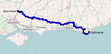
Start: | Eastbourne |
Finish: | Winchester |
Profile: | between sea level and 270m |
Rating: | Easy trails with few difficulties |
The South Downs Way is a footpath in England, running from Eastbourne, on the South Coast, approximately 100 miles to the city of Winchester. It mostly follows a ridge of chalk downland but also includes sea views and historical interest.
There are two alternative routes near the Eastbourne end of the trail, one along the coast via Seven Sisters, and one further inland past the Long Man of Wilmington. There are also options to cycle or ride horses along parts of the route.
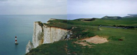 Chalk cliffs at Beachy head 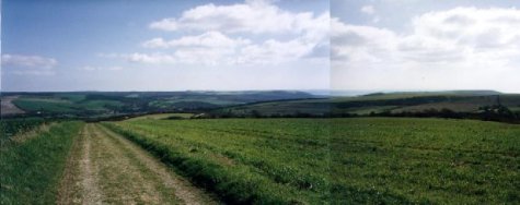 Open countryside at Alfriston |
Splitting the walk up into weekend sections requires careful planning. The route passes by several bus stops and train stations along the way, but not always at convenient intervals. Occasionally some diversions may be necessary to get to the next village, and local train services are likely to be sporadic on Sundays. Tools like Openstreetmap or Google Earth can help enormously with the preparations, as can a good guide book.
As one example, the 100 miles can be split up into 5 weekends with the access points at Eastbourne, Southease, Botolphs, Upwaltham, Buriton and Winchester.
There is a wide range of accommodation available, from camping places to B&Bs to country pubs and hotels. Again, some diversions may be necessary to get to the nearest village as the way does an amazing job of avoiding built-up areas.
Lists of accommodation possibilities are given on the National Trail site under "Planning a trip".
Eastbourne - Cuckmere - Alfriston - Firle Beacon - Southease - Ditchling Beacon - Botolphs - Upwaltham - Buriton - Butser Hill - Winchester
 |
This is a great route for many reasons. For one, it follows a ridge of hills which is very prominent, so the views are tremendous. Being able to see the sea is a bonus, as well as being able to see quite clearly where you've been and where you're going. The most spectacular views are on the Eastern section, where the surrounding land is so flat that you can see for miles. Plus, as you're walking along the ridge, you get sustained views without having to climb up and down too many hills.
The Way is very well signposted, for the most part, making it quite difficult to get lost, and as much of the land is high and well-drained by the chalk, it is not too muddy (apart from the section near the Meon River!). And as the route is in a fairly straight line, you get a real sense of covering a lot of ground, rather than just walking in a circle.
As the ridge is so prominent, and is so old, it has been a strategic focus for population and trade for centuries. Settlements, forts, tumuli, graves and field systems abound along the route, and the history of the places goes back through medieval times, to the iron age, the bronze age and even back to neolithic times. People have walked along the Way for thousands of years, and yet even now the tranquility and space is only occasionally broken by the busy roads of recent times. You can really get a sense of escape.
The following are extremely rough coordinates, obtained approximately from openstreetmap. They might be useful as a rough guide but certainly shouldn't be relied upon. They're also provided in a file south_downs_way.kmz which can be used in programs like GpsPrune or Google Earth.
                           Latitude       Longitude
    Eastbourne             N 50°46'09.6    E000°16'51.9
    Beachy Head            N 50°44'24.2    E000°15'07.3
    Seven Sisters          N 50°45'07.8    E000°10'54.2
    Littlington            N 50°47'38.3    E000°09'34.4
    Long Man of Wilmington N 50°48'34.6    E000°11'19.2
    Alfriston              N 50°48'23.8    E000°09'21.1
    Southease              N 50°49'52.9    E000°01'50.2
    Rodmell                N 50°50'07.0    E000°00'44.4
    Plumpton               N 50°54'11.0    W000°03'41.5
    Ditchling Beacon       N 50°54'07.3    W000°06'25.5
    Saddlescombe           N 50°53'20.0    W000°11'08.9
    Poynings               N 50°53'37.2    W000°12'19.9
    Botolphs               N 50°52'18.2    W000°18'00.7
    Chanctonbury Ring      N 50°53'48.9    W000°22'52.8
    Amberley village       N 50°54'29.4    W000°32'05.9
    Bignor Hill            N 50°54'38.2    W000°36'16.2
    Cocking Village        N 50°57'07.4    W000°45'05.1
    Beacon Hill            N 50°57'32.7    W000°51'07.0
    Buriton                N 50°58'38.6    W000°57'00.6
    Old Winchester Hill    N 50°58'51.0    W001°05'19.6
    Exton                  N 50°59'00.0    W001°07'41.2
    Cheesefoot Head        N 51°02'46.4    W001°14'43.2
    Chilcomb               N 51°03'06.5    W001°16'30.7
    Winchester             N 51°03'39.5    W001°18'28.6
See nationaltrail.co.uk's page for lots more information, including FAQs and links. Several book guides are listed in their "publications" page. There's also a small amount of information at Wikipedia. More recently, there's an interesting magazine article at BBC travel on a more "ghostly", roughing-it theme.
For more detailed route information, use the free map resources at openstreetmap and a free downloadable gpx file from lonvia.de.