
Hike time: | 3.5 to 4 hours |
Approx dist: | 10 km |
Start: | Cabo church |
Finish: | Cabo church |
Profile: | from 460m up to 640m, and back again |
Rating: | Easy |
This walk makes a nice loop around the western coast with a variety of scenery - firstly clifftops and sea views, then country lanes through the outskirts of villages, then a winding but flat levada, and then the road back to the starting point.
There's nothing tricky at all here, just a relaxing walk, although the straight climb up to the levada takes a little effort.
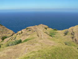 Path from the church at Cabo down to the lookout 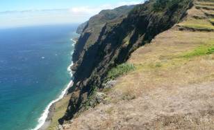 Coastline from the lookout 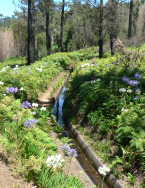 The flower-lined levada nova 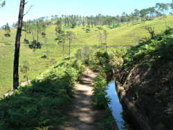 Levada following the contour lines |
The walk starts and ends at the church in Cabo. There is plenty of free parking space for your rented car, which is the best way to get there.
This kmz file (4 kb) contains waypoints from this Cabo hike and shows the path as a red line around the loop. Simply open it in Google Earth (File -> Open) and you'll see the route in full. Press the "Play Tour" button below the listed waypoints and you can fly a tour along the hike in 3d.
Cabo - lookout - levada nova - Cabo
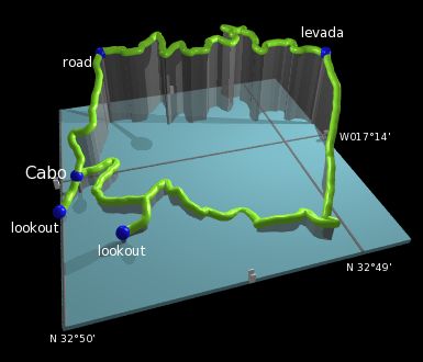 |
From the church at Cabo, the first irresistable goal is the footpath heading straight downhill towards the sea. This ends at a precipitous lookout point giving great views over the Atlantic and the rugged, windswept coast. This is just a taster of the walk to come as the real walk starts back at the church.
Back at the church again, follow the flat track southwards which winds through the trees until it reaches a crossroads. Here, the track to the right leads out towards the coast again to another lookout point, with steep cliffs and views towards the lighthouse at Ponta do Pargo.
After retracing the steps back to the crossroads, turn right again to continue on the original track, and follow it until it meets a road. Here, turn right and follow the road as it rises and falls over the rural scenery. The road curves left and right, but heads roughly southwest towards Pedregal, until you reach a left turn signposted for "levada nova". Follow this signpost left, and continue straight over the main road.
This road is extremely straight and climbs relentlessly directly up the fall line. It's only a 200m climb but in the summer heat can feel like more. Keep an eye out for the levada, which you'll see hidden in the ferns to the right of the road. Now find where it re-emerges on the left side of the road, and follow the footpath alongside.
The levada winds its way northwards through the thick ferns, seemingly in the middle of nowhere, yet decorated with beautiful wild flowers. Obviously the path is extremely flat being alongside the levada so walking is easy but some stretches are overgrown with ferns and tall grass.
Soon you approach the main road, which you cross and continue on the levada beyond right until the footpath ends. Here you reach a small road, which you can follow downhill to Cabo and shortly thereafter the church and car park.
The following are the coordinates for waypoints along this route, obtained from GPS. They can be used either in another
GPS, or along with a map, to provide additional references if necessary.
                           Latitude       Longitude    Altitude(m)
       Cabo Church        N 32°49'55.8    W017°14'05.4     458
       Lookout            N 32°50'00.5    W017°14'13.3     419
       Lookout2           N 32°49'47.5    W017°14'26.7     434
       Levada             N 32°48'48.3    W017°13'52.9     637
       Road               N 32°49'45.6    W017°13'32.7     633