
|
This Jomsom trek follows the Kali Gandaki river upstream through a wild and varied series of landscapes. The contrast from lowland 1000m greenery to 3800m almost lunar desertscapes is spectacular, and the surrounding snow-capped Annapurna mountains including Dhaulagiri and Nilgiri tower impressively overhead.
This trek forms part of the Annapurna circuit, and is essentially the final third of that circuit, done in reverse. The whole circuit is usually done anti-clockwise, coming over the Thorung La past Muktinath and Jomsom down to Birethanti, whereas this shorter Jomsom trek is usually done upstream with a flight back from Jomsom to Pokhara.
Doing a trek of this length rather than the whole circuit allows other activities (eg. sightseeing in Kathmandu valley, rafting trip, animal-watching in Chitwan) to be combined with a trek, without needing an inordinately long holiday. And this trek is excellently catered for in terms of accommodation (the "tea houses" and lodges) and cafes along the way, and the navigation is very straightforward.
As described here, the trek starts at Nayapul (new bridge) on the main road not far from Birethanti. From Pokhara this is around 30km by bus or taxi, and easily arranged. It's a popular start point for several treks so it's well known.
The highest and furthest point reached on this trek is the pilgrimage site of Muktinath, however the steps are retraced back to Jomsom where there is an airfield. Flights from here back to Pokhara are popular (usually early morning) and, weather-permitting and with luck, you can just turn up at the airport and buy a ticket. Alternatively, tickets can be bought in advance in agencies in Jomsom or Pokhara.
This kmz file (14 kb) contains coordinates from the Jomsom trek and shows the main track leading up the valley. Simply open it in Google Earth (File -> Open) and you'll see the route in full. Press the "Play Tour" button below the listed waypoints and you can fly a tour along the route all the way from Birethanti to Muktinath.
Note that this file was based on data kindly supplied by Frank Jones, together with additional info from Openstreetmap.
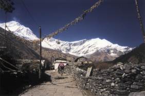 The wide, easy path somewhere near Marpha  Landscape above Kagbeni on the way to Muktinath |
Birethanti - Ulleri - Ghorepani - Poon Hill - Tatopani - Dana - Ghasa - Kalopani - Larjung - Marpha - Jomsom - Eklabathi - Muktinath - Jomsom
The following picture shows a 3d view of the route, starting from Birethanti and going up to Muktinath. It clearly shows the climb up to Poon hill, the climb from Tatopani up to Kalopani, and the much flatter route from there to Jomsom.

With the number of accommodation offers along this route, each trekker can go at their own pace and arrange their trek appropriately. Some people take up to 16 days to do this route, some people take half that. The breakdown given here is only a suggestion. Note that the climb up to Ghorepani and the climb down the other side to Tatopani are both hefty and energy-sapping.
Day 1 starts from the bus stop at Nayapul and the signposts lead already towards Birethanti. It's only around half an hour to this village, with its cafes and German bakery. Here is where the paths split, with the Ghandruk trek leading northeast up the Modi valley, and this Jomsom trek taking a left turn uphill to the northwest, towards Ghorepani. The valley is quite narrow here and the legs are getting used to the climbing with packs. At around 1400m you reach Sudame/Hille, where the first night's tea house awaits.
Day 2 is a tough climb, and a long day if extended all the way up to Ghorepani. The path is wide and well-maintained but it's more of a staircase on the way up through Ulleri and requires hard work.
It's customary to get up early in Ghorepani to catch a sunrise from the top of Poon hill, but that goal is made difficult by the hard climb of the day before and the early rise of the sun. By climbing after the sunrise hordes have finished, you also get the whole beautiful panoramas to contemplate alone rather than as part of a herd. After that, it's all downhill on day 3, a long long descent through Ghara to meet the Kali Gandaki at Tatopani. This descent is also steep and tiring but provides first glimpses of Nilgiri ahead.
Day 4 ascends again, but more gradually, following the river upstream through Dana, and through some rockier sections on the way up to Ghasa.
Day 5 offers some amazing mountain views on the way out of Ghasa, with hosts of snow-capped giants looming overhead. Beyond Kalopani, a watery section then leads uphill to Larjung.
After Larjung the valley becomes much flatter so it's easier to cover more ground if you want. It's easy, riverside walking to Marpha, and not much further to Jomsom as the river becomes wider, flatter and slower, and the landscape becomes more desert-like. Or, if the legs are still willing, you can push on past the rather soulless Jomsom to spend the night at Eklabathi.
For the final push up to Muktinath, one can of course leave all the heavy stuff behind and just make a day jaunt up and down again. From Eklabathi it's a lunar or even Mars-like, sandy landscape, on the steep final ascent, around 900m up and down. The final pilgrimage site is other-worldly, with its silent, awe-inspiring surroundings and mysterious natural flame. Without the heavy pack it's an easy hike back down to Eklabathi again.
The last leg is then just the 4km or so back down alongside the broad lazy river to Jomsom airport for the flight back to Pokhara. Unfortunately due to the local weather conditions (ie wind), most flights leave before 8am so it needs an early start.
The following are approximate coordinates for waypoints along this route, obtained from maps and internet resources. They can be used either in a GPS receiver, or along with a map, to provide additional references if necessary.
                            Latitude       Longitude    Altitude(m)
        Nayapul/Birethanti N 28°17'59"     E083°46'14"     1060
        Ghorepani          N 28°24'09"     E083°42'02"     2880
        Poon hill          N 28°23'56"     E083°41'18"     3210
        Tatopani           N 28°29'50"     E083°39'12"     1255
        Ghasa              N 28°35'38"     E083°38'38"     1960
        Kalopani           N 28°38'13"     E083°36'17"     2500
        Marpha             N 28°45'12"     E083°41'12"     2680
        Jomsom             N 28°47'04"     E083°44'07"     2770
        Eklabathi          N 28°49'06"     E083°46'26"     2870
        Muktinath          N 28°49'00"     E083°52'18"     3790
Wikipedia has some information in English about the Kali Gandaki valley and the mountain Dhaulagiri. For the whole three-week circuit, see the Annapurna circuit.
According to Austin Pick's page, there's a road-building project underway in the upper Kali Gandaki, all the way up to Muktinath, which for some could spoil the whole trek. Walking along a road dodging motorcycles isn't quite the same as trekking along a remote footpath in a wild valley. Check out the latest situation before deciding on a route.