
GpsPrune is available to download from the downloads page, with the latest released version being version 23.2. This page describes some of the features which are new with this version.
For information about the forthcoming version, see the development page.
Version 23.2 is obviously also just a minor release with no new functionality, just bug fixes and small improvements.
Version 23.1 is obviously just a minor release, with no new functionality, just bug fixes and small improvements. There were a few additional translations too, especially for Italian and Portuguese.
sym tag for the symbol (Issue 72)
The most obvious change with version 23 is the new icons. The icons in the toolbar were due for an overhaul, and we took the opportunity to move to a completely svg-based set of new icons so that they're not fixed to a single resolution. The first step is to make the existing icons more uniform and consistent, as shown in these early screenshots. And yes, the icons aren't as colourful as before but they do have a subtle "prune" hint to them.
Presumably, with a future version there will be some kind of setting to choose which size icons to use, with a choice between these ones (roughly the same size as the current ones) or double sized. In this way, those users with huge screens and tiny pixels will be able to choose larger images for the buttons and controls if they wish.
Many thanks to fontawesome.com for the new icons - and for providing them under a CC-BY license! 
There was also a series of changes to the invisible mechanisms behind the scenes which fundamentally change the way that all the functions work but so far hasn't added any new features at all. So you could reasonably ask "why bother?". Because there are some invisible benefits on the testing side, making things much easier to test than they were before, so a lot of new tests became possible. Plus it triggers some cleaning and separating activities which have reduced the code and will hopefully make maintenance simpler. And the big reward, right at the very end, will be the addition of a "Redo" button next to the "Undo" button in the toolbar. I know, I know.
There were a couple of casualties of this upheaval though. The function "Convert waypoints to timestamps" got removed, mainly because I haven't used it or wanted to use it for a long time. And a second was the "select tracks" dialog which came up when loading a gpx file containing multiple named tracks. This was originally introduced because it was something I often wanted to do (due to receiver hardware behaviour); I haven't used it for a long time so I'm guessing (hoping) that others don't either.

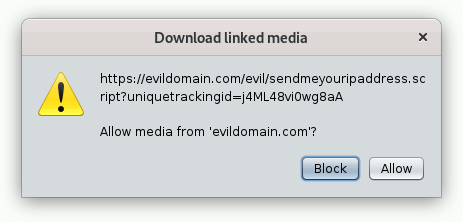
Meanwhile.... a kml file provided by a restaurant owner in Germany brought to my attention the possibility that specially crafted links in such kml or gpx files could be misused in the wrong hands. Not that this particular individual was misusing them, but it turned out that a lot of requests were being made without my knowledge. So here is a new confirmation popup with version 23, to make sure that you know what you're downloading and that you're agreeing to it. I think that if they're being used legitimately, the linked media (photos and/or audio files) will all come from a small number of domains, and you only have to click 'Allow' or 'Block' once for each domain, so I believe that it's a low overhead for real use cases. The allowed and blocked domains aren't currently stored though, so they're only remembered until you close GpsPrune. As always, feedback on this proposal is welcome.
Another little feature, in the "Point" menu there's now a new "Go to" submenu, with three entries - highest, lowest and fastest (slowest doesn't really make sense I think). Click on one of those, and the corresponding point in the track will be selected for you. This makes it much easier to find that one crazy point with an altitude of -1500m, or that little section of track with crazy high speeds. Or just quickly find the peak of the mountain without hunting through the altitude profile. Obviously if you haven't got speeds or timestamps then you can't select the fastest, and if you haven't got altitudes then you can't select the highest or lowest.
Now, imagine you've loaded points from several different files, and some waypoints are defined in several of the files. Once you load them all, you've got duplicates of some of your waypoints. It would be nice to remove the duplicates, so that each waypoint only appears once. This sounds straightforward, but it also has to handle the case where one file has the waypoint without an altitude, and another file has it with. Or with an additional comment, or description, or type. In this case it shouldn't necessarily just delete the second instance, because that might have more information than the first. So it's more involved than it at first sounds, but it deliberately doesn't merge the points together so that you know what happened. It appears as a new function under Track -> Remove duplicate waypoints.
Of course, the user guide has also been updated, and has expanded up to 184 pages. All the functions mentioned here are described in detail in the user guide, including screenshots and explanations.
See the development page for details on what's coming with future versions.