
 |
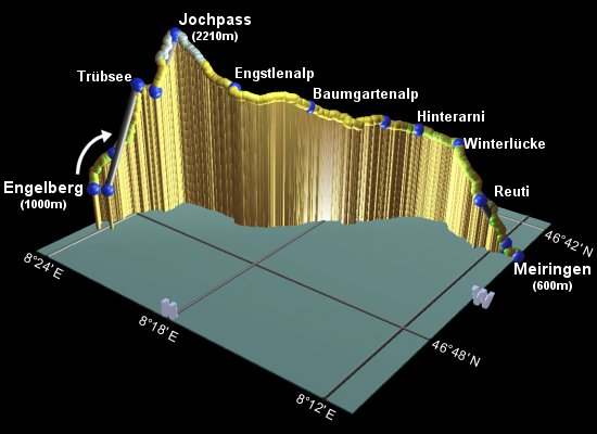
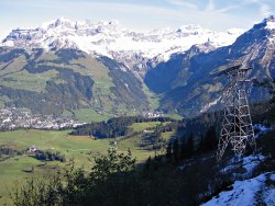
This is the fifth stage of the Alpine Pass Route. It starts from Engelberg, in central Switzerland, and crosses the Jochpass over to Meiringen in the Eastern Berner Oberland. The variety of scenery here is impressive, climbing up through a ski resort and traversing a beautiful U-shaped valley towards craggy snow-capped peaks. It passes two small idyllic lakes, the Trübsee and the Engstlensee, and views the Brienzersee from a distance, with just a glimpse of the Eiger towards the end.
As it is described here, split into two days' walking with an overnight at Engstlenalp, each of the days is a comfortable length with not too much climbing or descending. If you wanted to make the trip in a single day, you'd be advised to take advantage of the gondolas, cable cars or chairlifts along the way to reduce the climbing.
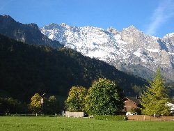
The photos here show rather more snow than previous sections - this is not because it's higher (it isn't), it's just because the photos were taken in mid-October not long after a snowfall.
Engelberg is reached by train in around an hour from Luzern, with connections at Stans. From the end of the walk in Meiringen, there are many transport connections, including the Brünig pass over to Luzern, or along the Brienzersee to Interlaken. There are also postbuses running between Engstlenalp and Meiringen, should you wish to do only one of the stages.
From Zürich, both journeys involve a change in Luzern, with the Engelberg trip taking about 2h10 and CHF17, and the trip from Meiringen back to Zürich taking about 2h20 and CHF19.
For Engelberg, try engelberg.ch, or the youth hostel. For Engstlenalp the Hotel Engstlenalp is recommended for a friendly welcome, clean dorm rooms (CHF35) and private rooms (from CHF55), and a spectacular setting. For Meiringen, Hasliberg and other places in this area, there are lists of hotels at alpenregion.ch.
Engelberg - Trübsee - Jochpass - Engstlenalp - Baumgartenalp - Reuti - Meiringen
Hike time: | 5.5 to 7 hours |
Approx dist: | 11 km |
Start: | Engelberg station |
Finish: | Engstlenalp |
Profile: | from 1000m up to 2210m, then drop to 1840m |
Rating: | easy to medium |
Outside the main entrance of Engelberg station, a large map and a set of signposts direct you down the road to the right,
towards Bänklialp, Trübsee and Jochpass. A path shortly leaves the road to the left, from which you fork right
on a tree-lined path cutting diagonally across the fields. The hotel/restaurant Bänklialp should just be visible
through the trees on the slope ahead. Continue past Bänklialp Hohlbrücke, still following the signs for
Trübsee and Jochpass.
Scenery as the path leaves Engelberg
Path across meadows near Gerschnialp towards Trübsee
Climb up past the left-hand side of the restaurant Bänklialp, zigzagging up through the trees to emerge in cow-filled pastureland. Follow the track across the level fields towards the cable car wires (stage 2 of the mechanical ascent, after the initial gondola ride). The restaurant Gerschnialp at Vorder Stafel is reached in around 45 minutes from Engelberg station.
Ahead you can see the buildings and cable car machinery high up atop a seemingly sheer cliff.
Needless to say, after crossing the plateau, the path steepens again and zigzags up underneath the
cable car wires. Eventually you emerge into the sunlight at the top cable car station after around
another 1h40.
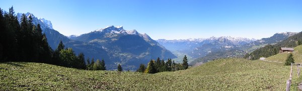
Panorama from near Gerschnialp
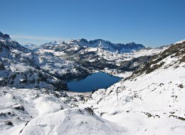
View down from near Trübsee
The surprisingly clear lake is over to the right, with a chairlift running across the edge of it.
Follow the signposted track running along the lake side, admiring the dramatic rocky landscape
surrounding this flat bowl. The almost horizontal chairlift (the "Trübsee Hopper") makes the third
stage of the skiers' journey, but doesn't run out of season. If there are skiers or boarders here in the
Summer, they'll probably be heading up to the left for the glacier skiing higher up.
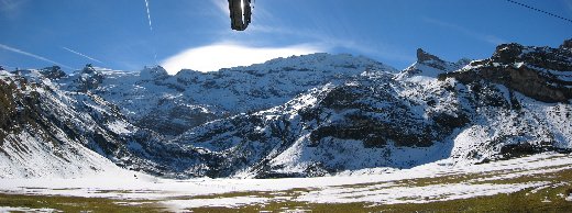
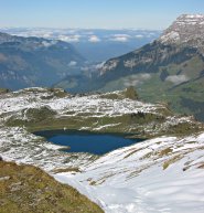
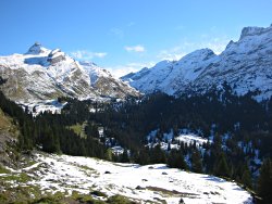
Snowy panorama at Trübsee
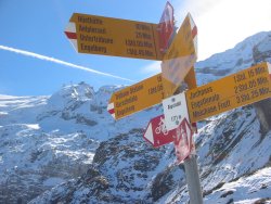
Signpost at Alpstubli with Titlis beyond
An easy 15-minute stroll along this track brings you to the restaurant Alpstübli and the base of the next chairlift, running up to the pass itself.
The path up is signposted as 1h15, but with October snow it can take a while longer. It's clearly marked
with red and white markings, climbing steadily up to the left of the chairlift. Throughout the climb,
the views back down to the Trübsee and the long, long drop down to the valley beyond are quite
spectacular.
Trübsee
Trübsee and distant clouds
Shortly you can see the summit of the pass, with the top chairlift station and a couple of restaurants.
It's not exactly a pristine, remote pass, but you'll know that already if you've ridden up in the Winter.
It does have great views though, back out to the cloud-covered valleys and ahead past (yet) another
chairlift down the other side of the pass.
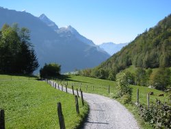
Descending towards Engstlensee
View back towards the Jochpass
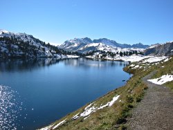
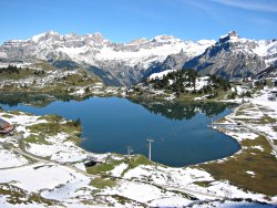
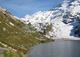
Sparkling Engstlensee
Following the fifth (and last) bit of skilift machinery of the day, drop down underneath the chairlift
wires towards Engstlenalp. This path zigzags down the valley marked with red and white posts and paint
splashes. Crossing several streams, it winds down towards the shimmering Engstlensee and eventually
meets it on the right-hand shore. Ahead, just past the large and beautiful lake, is the peach-coloured
Hotel Engstlenalp, which the path meets after a brief detour round the car park. The bus stop is just
outside the front of the hotel, reached in around 1h30 to 2h from the pass summit. Again this can
depend on the snow, but generally the snow on this side of the pass will be softer than the more shaded
bits on the ascent.
Hike time: | 5 to 5.5 hours |
Approx dist: | 19 km |
Start: | Engstlenalp |
Finish: | Meiringen |
Profile: | from 1800m down to 600m |
Rating: | easy to medium |
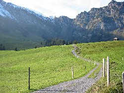
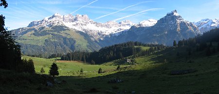
Immediately from Engstlenalp, the dramatic convoluted form of the Engelhörner range draws the eyes ahead down the valley of the Gental. The signposts at the bus stop outside the hotel direct you slightly upwards on a narrow road towards a cluster of barns, towards Hasliberg/Reuti and Baumgartenalp. This road turns into a track curving round to the left, past the noisy waterfall.
View back towards Engstlenalp
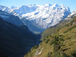
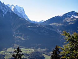
Looking down the valley to the Engelhörner
When the path forks, take the left branch towards Baumgartenalp and Hasliberg/Reuti, and a short distance later take a second left fork, again towards Hasliberg/Reuti. This path is fairly narrow and occasionally uneven, but quite level as it drops only gently down to Baumgartenalp after around 1h30.
Continue to follow the signs for Hasliberg/Reuti down a narrow road, until a signpost directs you rightwards
on a path traversing high above the deep U-shaped valley.
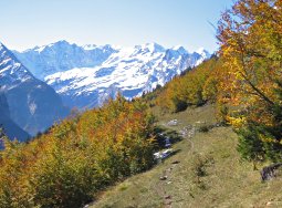
Fiery Autumn colour in the Gental
Intriguing shape of the Urbachtal
Unterbalm, after around 1h10, turns out to be just a single hut with a water trough, from where the path
continues on an easy track through the fiery Autumnal trees, as a second valley joins our Gental from the
left. This second valley leads eventually up to the Sustenpass, another of the many important passes in
the area. After around 30 minutes you reach a cluster of houses at Hinterarni.
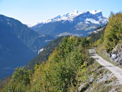
Track curving towards Reuti
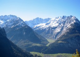
Panorama from Winterlücke, including Grosse Scheidegg and the Brienzersee
Continue onwards, following the signposts to Winterlücke, as you begin to round the corner into
the main Meiringen valley. More side valleys appear, including the one up towards the Grimselpass and
the interestingly-shaped Urbachtal. As you reach Winterlücke, after around 45 minutes, the views
open out to a massive panorama including Grosse Scheidegg
(the next pass on this route) and the distant Brienzersee.
Looking ahead to the Grosse Scheidegg
Track descending towards Meiringen
Follow the road, and take the signposted fork towards Reuti. You can briefly glimpse the Eiger beyond the Grosse Scheidegg as it sidles past. A signposted path drops down to the left of the road, shortly meeting it again and taking a "direkt" path at Ober Schletter.
As the resort town of Reuti comes into view with the large cable car station, a signposted track cuts
down to the left towards Meiringen (for a cable car descent, just stay on this level road to meet the obvious
building around 50 minutes from Winterlücke).
Passing through the edge of the town, a mixture of paths and tracks drops down easily to
Alpbach right by the lower cable car station, around an hour from Reuti, from which it's a 10-minute walk
through the town of Meiringen to the station.
The following are the coordinates for waypoints along this route, obtained from GPS. They can be used either in another GPS, or along with a map, to provide additional references if necessary.
                           Latitude       Longitude    Altitude(m)
       Engelberg Station  N 46°49'11.2    E008°24'10.3     994
       Vorder Stafel      N 46°48'30.4    E008°24'03.3    1257
       Trübsee            N 46°47'37.7    E008°23'50.1    1796
       Alpstubli          N 46°47'26.1    E008°23'17.8    1771
       Jochpass           N 46°46'42.5    E008°23'12.3    2207
       Engstlenap         N 46°46'31.6    E008°20'40.4    1837
       Baumgartenalp      N 46°45'31.0    E008°18'28.0    1702
       Unterbalm          N 46°44'13.8    E008°16'28.4    1551
       Hinterarni         N 46°43'32.3    E008°15'36.8    1459
       Breitlaui          N 46°43'16.3    E008°14'31.7    1370
       Winterlücke        N 46°43'20.8    E008°14'02.2    1395
       Ober Schletter     N 46°43'42.3    E008°13'23.0    1230
       Reuti              N 46°43'58.7    E008°12'32.5    1060
       Grini              N 46°43'45.1    E008°12'18.6     980
       Alpbach            N 46°43'40.1    E008°11'35.1     620
       Meiringen Station  N 46°43'39.3    E008°11'03.4     595
The Hotel Engstlenalp has information about the area, including pictures, and the hotel itself has great leaflets showing panoramic maps and walking routes around the Hasliberg and Gental regions. These should also be available at tourist offices and stations. titlis.ch has a Summer map showing the route up to the pass, alpenregion.ch has a map of the second day down the Gental, and there's a panoramic drawing at winterspass.ch (600kb pdf file) showing the whole route.
For other activities in the area, there's a shorter walk from Reuti to Brünigpass, or there's snowboarding at Titlis and snowboarding at Hasliberg.