
Hike time: | 6.5 to 7 hours |
Approx dist: | 25 km |
Start: | Dielsdorf station |
Finish: | Brugg station |
Profile: | Between 320m and 870m, |
Rating: | Mostly easy except for some tricky bits on Lägeren (narrow, rocky path) but long |
Greetings: | Grüezi |
This page describes the first day of this ridgeway walk, from Dielsdorf to Brugg. Some may prefer to break this up into two days, with Baden being an obvious intermediate stop. The first part climbs up from Dielsdorf via Regensberg to the Lägeren ridge, eventually dropping down to Baden. The second section climbs again, over the Gebenstorfer Horn and finishes with a level riverside stretch into Brugg.
Dielsdorf, Baden and Brugg are all connected to Zürich with regular, direct trains.
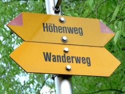 Clear markings for the Höhenweg 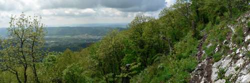 Watch your step on this bit of the footpath 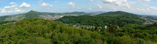 Looking back from the tower at Baldegg towards the Lägeren ridge (on left) |
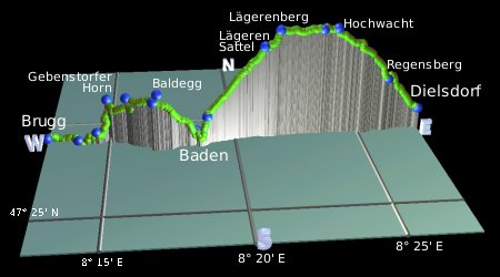 |
Dielsdorf - Regensberg - Lägeren - Sunnenberg - Baden - Baldegg - Gebenstorfer Horn - Brugg
Almost all of the signposts along the way have red 'flashes' on the markers, and these start immediately outside Dielsdorf station. Follow them along the road away from the station, and make sure you follow them rightwards after around 50 metres opposite the Falken pub. There's a twisty stretch through the backstreets and alleyways of Dielsdorf, before popping out by a busy road. Take care crossing this road, it's hard to see what's coming round the corner!
On the other side of the road, the way follows a track, and climbs away from the town. Passing between gardens and vineyards, it steepens sharply on the final approach to Regensberg, with its immaculate houses and lawns, idyllic atmosphere and prominent tower. From here you get a great view out over the wooded landscape stretched out over 150m below.
Continuing under the bridge, the signposts lead on forest paths, climbing steadily but with only intermittent views. Eventually you pass a strange black golf ball-like communications tower, shortly before the restaurant Hochwacht. Just to the left of the restaurant, metal railings lead out onto a viewing platform with spectacular panoramas over the plain, including the Uetliberg and the Zürichsee, and depending on the visibility even further to the likes of Rigi and Säntis.
From Hochwacht the path begins a flat and straight-westwards section, following the top of the narrow ridge. It's quite heavily vegetated but the occasional views southwards are expansive. Once you reach Altlägeren, the path begins a red-and-white-marked Bergweg, which indicates that it's a bit trickier and rougher than the earlier tracks. There are several sections with uneven rocks, narrow paths and steep drops to the sides which need a bit of care here. The path makes a beeline for Lägeren Burghorn from where you get wonderful open views to both sides of the ridge, southwards as before and also over the rather flatter landscape to the north.
From Lägeren Burghorn the still rocky Bergweg drops to Lägeren Sattel, and then follows an easier track steadily downhill to Sunnenberg. Turn left here, and climb the wooden steps to Schartenfels with its view overlooking Baden and the Limmat river. To the north of the city centre it gets pretty industrial, however. From here the path leads down the road a short way and then onto a path leading quite steeply downhill to the river. Cross the river over the impressive covered wooden bridge and follow the flashes through the picturesque Baden streets. At the time of writing there's a fair bit of construction going on, blocking off the recommended route, so you may find yourself at a dead-end in the back streets. If you find Badstrasse though, just follow this main shopping street and it'll lead to a set of signposts, guiding you leftwards to the main railway station.
From Baden station, the signposts lead along the platform and then under the tracks to a looong set of steps climbing up the other side. A steady climb through the forest leads to an interesting water tower which you can climb for a spectacular view from the top. It's a hefty climb up the spiral stairs but well worth it for the view back to the Lägeren ridge and the onward route. Shortly after the tower is the restaurant Baldegg, with a large outdoor seating area. Go around this restaurant and into the thick forest once more, following the wide tracks past a picnic area. Some more weaving through the forest tracks and a gradual descent from Chörnlisberg brings you to the Gebenstorfer Horn, another prominent lookout point. From here you can see the Limmat river (from Zürich and Baden) joining the Aare river (from Biel and Solothurn) and just out of view the Reuss river (from Luzern) joins as well. This makes an important meeting point for a huge catchment area of Swiss rain.
Leaving the Gebenstorfer Horn, the path drops down to meet the river Reuss, and follows the riverbank (a low Höhenweg indeed!) upstream to the Reusssteg, an impressive set of wiers and sluices. There's a lot of water being churned around here. After crossing the bridge, the path follows the railway track and then comes out on the bank of the Aare, again following the riverbank to the edge of Brugg. Here the red flashes lead in both directions - leftwards is the shorter way to Brugg station, cutting through side streets to the end of the platform. There are frequent connections to Zürich from here, some of them trains and some slightly slower S-bahns.
The following are the coordinates for waypoints along this route, obtained from GPS. They can be used either in another GPS, or along with a map, to provide additional references if necessary.
                          Latitude       Longitude      Altitude(m)
     Dielsdorf           N 47°28'57.6    E008°27'31.4     428
     Regensberg          N 47°28'56.0    E008°26'10.9     593
     Hochwacht           N 47°28'54.1    E008°24'03.0     856
     Altlägeren          N 47°28'53.3    E008°23'29.6     855
     Lägerenburg         N 47°28'50.9    E008°21'48.1     859
     Lägeren Sattel      N 47°28'47.4    E008°21'10.9     785
     Sunnenberg          N 47°28'31.5    E008°18'54.3     432
     Schartenfels        N 47°28'28.1    E008°18'52.8     464
     Baden station       N 47°28'34.9    E008°18'28.1     385
     Baldegg             N 47°28'12.9    E008°16'46.3     569
     Chörnlisberg        N 47°28'45.4    E008°15'43.7     553
     Gebenstorfer Horn   N 47°29'12.8    E008°14'56.4     514
     Reusssteg           N 47°28'48.7    E008°13'46.0     335
     Unter Windisch      N 47°28'58.1    E008°13'36.8     345
     Brugg station       N 47°28'51.6    E008°12'32.6     349
To view this hike in Google Earth or Google Maps, see the Kmz file for the whole Jura Ridgeway on the main page.
The next section on this hike is Brugg to Salhöhe.