
Hike time: | 5 hours |
Approx dist: | 17 km |
Start: | Sainte Croix |
Finish: | Ballaigues |
Profile: | Between 860m and 1530m, |
Rating: | Mostly very easy |
Greetings: | Bonjour |
This page describes the thirteenth day of the Jura ridgeway walk, from Sainte Croix past Le Suchet to Ballaigues. The highlight is definitely the panoramic stretch over the ridgetop by Le Suchet with views over Lac de Neuchâtel and Lac Leman, with the Alps beyond.
To get to the start of the day's hike at Sainte Croix, there are trains from Yverdon-les-Bains with plenty of long-distance connections. For Ballaigues there are buses from Vallorbe.
For Ballaigues, I can recommend the Hotel de la Croix d'Or for simple, good value rooms and very friendly service. Single rooms cost 55 CHF including good breakfast. Reserve by phone if possible, email is unreliable.
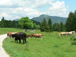 Looking back towards le Chasseron 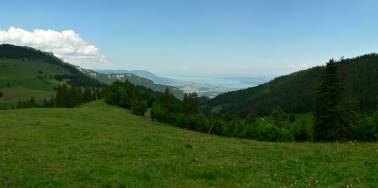 Panorama towards lake Neuchâtel 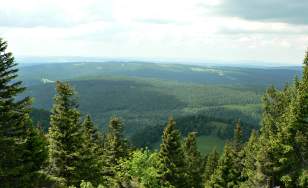 Looking north towards France 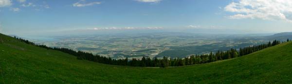 Panorama southwards towards Alps from near Chalet du Suchet |
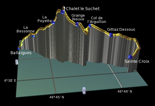 |
Sainte Croix - La Gittaz Dessous - Col de l'Aiguillon - Grange Neuve - Chalet du Suchet - La Poyette - La Bessonne - Ballaigues
From the train station at Sainte Croix, the signpost opposite points along the road to the left, which then swings round rightwards and skirts the edge of town. Occasional yellow markers lead the way unexpectedly northwards up a busy road, before the green "5" signs lead you leftwards up a path across the fields.
With Sainte Croix below to the left and a wooded ridge ahead, the track climbs slowly with occasional glimpses of Lac de Neuchâtel, leading to a road to Cafe de la Gittaz.
The quiet lane emerges from the trees with a forested ridge to the left. It leads first along, then towards, and finally around the end of this hump, reaching the pass of Col de l'Aiguillon with its massive concrete tank obstructions.
The lane descends steeply on the other side of the col, bending round to the east underneath steep cliff walls. From the road, a path cuts right down into the dip and round up the other side, resuming the southwestward direction and regaining views of the lake behind.
From Grange Neuve, a path leaves to the right of the road and begins to climb again, gaining more lake views. The rooty path climbs steeply to the ridgetop at around 1530m, just below the summit of Le Suchet. The signposts bypass the actual summit (1588m) to go straight down to the Chalet below, but the small detour is worth it for the views.
Even from the Chalet, and especially from the level section of path beyond, the panoramic views over the patchwork plain below and the two massive lakes on either side, with the Swiss and French Alps in the background, are stunning. It's also a popular spot for paragliders to take off, and gliders patrol the ridgetops looking for the same invisible currents.
Take the level path (not the one leading up to the cross) and enjoy the spectacular views unfolding. Eventually the path starts to descend, and makes its way down to La Poyette. There's an awkward set of 3 gates here, following which the path goes straight across the next junction and dives into a wood.
The gradual descent continues, emerging from the wood and following tracks and roads marked with yellow diamonds through La Bessonne. As it approaches Ballaigues, the roads zigzag down to the village, arriving just opposite the hotel de la Croix d'Or.
The following are the coordinates for waypoints along this route, obtained from GPS. They can be used either in another GPS, or along with a map, to provide additional references if necessary.
                          Latitude       Longitude      Altitude(m)
     Sainte Croix        N 46°49'10.2    E006°30'04.1    1066
     La Gittaz Dessous   N 46°48'26.9    E006°28'37.1    1239
     Col de l'Aiguillon  N 46°47'29.8    E006°27'57.6    1320
     Grange Neuve        N 46°46'48.3    E006°28'09.7    1356
     Chalet du Suchet    N 46°46'06.6    E006°27'53.8    1490
     La Poyette          N 46°45'41.7    E006°27'12.1    1338
     La Bessonne         N 46°44'41.1    E006°25'44.5    1090
     Ballaigues          N 46°43'47.1    E006°24'57.0     862
To view this hike in Google Earth or Google Maps, see the Kmz file for the whole Jura Ridgeway on the main page.
The next section on this hike will continue from Ballaigues to Le Pont.