
Hike time: | 5 hours |
Approx dist: | 15 km |
Start: | Orvin bus stop |
Finish: | Chasseral hotel |
Profile: | Between 670m and 1600m, |
Rating: | easy |
Greetings: | Bonjour |
This page describes the eighth day of this ridgeway walk, from Orvin to the hotel on the Chasseral. It's more or less the same as the Chasseral day hike but in the opposite direction and without the gorge of Combe Grède. It's got quite a lot of uphill, but it's steady and gradual, and is mostly on easy tracks.
Orvin has good bus connections to nearby Biel/Bienne on the main express line. The hotel at Chasseral has buses to St Imier on the train line to Biel/Bienne, but the last one is currently at 4:40pm.
The hotel Chasseral is one good option for overnighting at the end of this stage - as well as rooms they also have dormitories for CHF 40 including breakfast.
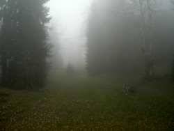 Foggy woods on the ascent 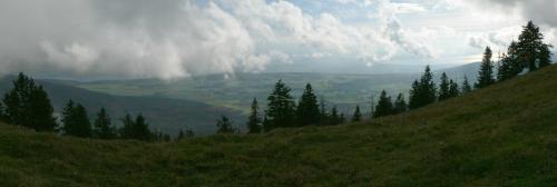 Panorama over the three lakes of Biel, Neuchâtel and Murten 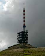 Tower on Chasseral summit 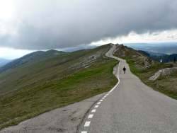 Road from the summit of Chasseral down to the hotel |
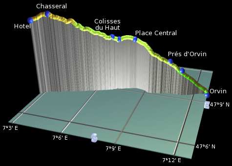 |
Orvin - Voigières - Prés d'Orvin - Place Central - Clédar Pierrefeu - Colisses du Haut - Chasseral - Chasseral Hôtel
In the village centre of Orvin, don't miss the village bakery just next to the bus stop, with fresh bread and supplies for the hike, and friendly service. Then follow the road opposite uphill to join the route from the last section, signposted for Prés d'Orvin.
Back on the route, follow the track towards Voigières climbing steadily. The track shortly meets a road, crosses it, and continues to climb on the other side. Eventually it meets a quiet lane and continues up it to Prés d'Orvin past a number of club huts and suburban chalets.
Bearing right across the open fields, the autumn colours of the trees can be quite eye-catching. Follow the track on to Crête de Chasseral and then the car park at Place Central. Here is where you join the ridgetop that makes a beeline for the Chasseral summit.
There follows a rare downhill stretch to reach Clédar de Pierrefeu, but the height is quickly regained on the way up to Les Colisses du Haut. The path follows the ridgetop straight towards the summit, but the tower appears and disappears behind the bumps. Meanwhile the scenery unfolds to the left, showing the three lakes of Biel, Neuchatel and Murten, and depending on the visibility, also the Alps beyond.
The final climb up to the tower at Chasseral is very open and pleasant, with lots of views over the plain to the south and also over the ridges to the north. The tower is a massive and rather ugly telecommunications hub, but extremely impressive up close. Once you get there, there's a panorama board showing some French and German peaks to the north, and some of the peaks already passed on this route such as the Weissenstein and Hasenmatt. Strangely no board for the southern views though.
Having reached the highest point of the day's hike, it's then just a gentle stroll for 20 minutes down the paved road to the hotel Chasseral. Here you'll find a spacious self-service restaurant with panoramic views from the terrasse, and a bus stop with services to St Imier (check the times!). There's also dormitory accommodation for CHF 40, including a reasonable breakfast.
The following are the coordinates for waypoints along this route, obtained from GPS. They can be used either in another GPS, or along with a map, to provide additional references if necessary.
                          Latitude       Longitude      Altitude(m)
     Orvin               N 47°09'38.7    E007°12'50.3     669
     Voigières           N 47°09'21.3    E007°11'12.8     975
     Prées d'Orvin       N 47°09'21.3    E007°10'27.6    1069
     Place Central       N 47°09'20.2    E007°08'13.6    1288
     Clédar Pierrefeu    N 47°09'05.5    E007°07'20.7    1293
     Colisses du Haut    N 47°08'57.5    E007°06'57.5    1325
     Chasseral           N 47°07'59.5    E007°03'35.9    1603
     Chasseral Hotel     N 47°07'38.0    E007°02'45.1    1548
To view this hike in Google Earth or Google Maps, see the Kmz file for the whole Jura Ridgeway on the main page.
The next section on this hike is Chasseral to Vue des Alpes.