
Hike time: | 7 to 7.5 hours |
Approx dist: | 23 km |
Start: | Môtiers station |
Finish: | Noiraigue station |
Season: | Summer |
Profile: | from 740m up to 1460m, and back down again |
Rating: | mostly medium difficulty, but quite long |
Greeting: | "Bonjour" |
There are two highlights to this walk, a dramatic and exciting climb up the Poëta Raisse gorge, and the simply stunning Creux du Van cirque. Either would make a good hike in itself, but both together make a very memorable day out. Both together also make for quite a long walk, however, and the bits inbetween, although extremely pleasant, are more a way of connecting the two highlights together.
Most of this walk is easy, but care is required in the gorge, and on the descent down to Noiraigue at the end. But if you can cope with the length of the walk, and the amount of climbing, this is a very special walk that's highly recommended.
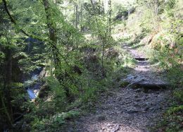 Path heading up towards the gorge 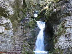 Stairs up beside the waterfall 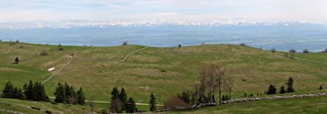 Quite an expansive view from the summit. Yes, those are the Swiss Alps. 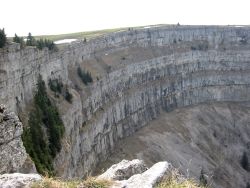 The spectacular cliff walls of the Creux du Van 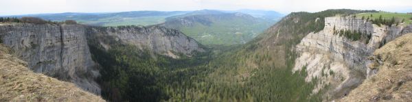 This amazing cirque just won't fit in the viewfinder |
Both Môtiers and Noiraigue lie on the same train line West from Neuchâtel - Môtiers around half an hour away and Noiraigue around 20 minutes. Trains run roughly hourly on this route through Travers, sit on the left from Neuchâtel for the views.
From Zurich, there are regular direct trains to Neuchâtel, making the journey time to Môtiers around 2h30, and the return time from Noiraigue about the same. For a ticket, a Tageskarte is highly recommended - amazingly it costs exactly the same price (CHF 52) as the complex combination of return and single tickets, but obviously with much greater convenience and flexibility.
For a zoomable, scrollable map of this hike, see this online map using Openstreetmap or Opencyclemap.
You can also download this kmz file creux_du_van.kmz to open it in programs like Google Earth or GpsPrune and then transfer the track to your GPS.
Môtiers - Poëta Raisse - La Combaz - Les Rochats - La Baronne - Le Soliat - Noiraigue
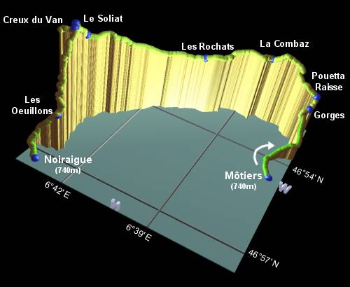 |
From the train station at Môtiers, follow the signposts for Poëta Raisse and La Combaz, following the "Grande Rue" Southwards out of the village. Continue until the path reaches the trees, at which point take the right turn signposted Poëta Raisse heading upstream. The gorge gradually gets deeper as you climb, following the easy (but steep in parts) path with its steps and railings. Continue past the simple signpost, heading upstream towards La Combaz. Take the steps up the left-hand side of the eager falls to reach a signpost marked "Gorges de la Poëta Raisse". In this most dramatic section of the gorge, the exciting route includes very narrow walkways, steep steps, railings, and even sections of snow (in early May), zigzagging up the gorge to emerge at the signpost "Pouetta Raisse" after around 1h30.
Follow the signs towards La Combaz, following at first a track and then a road. At the signpost, turn left towards La Combaz, descending on a track through the trees and then crossing the fields to reach the restaurant at La Combaz after around 45 minutes.
Follow the road, signposted Les Rochats, and then cut back to the right on a signposted track. Look out for the red-and-yellow markings. The path goes through a gate marked "Chemin Prive", and through a silent, tranquil valley, before dropping down across a field to meet a track. Go left here, until it meets a road, and then continue downhill to the restaurant Les Rochat after around 1 hour.
Continue past the front of the restaurant, following the signpost for Le Soliat. Shortly the signs will point you off to the left, along a rooty path through the trees. After crossing a road, and twisting further through the forest, it emerges into open fields with clumps of trees. Keep straight ahead, looking out for the red-and-yellow signs on the trees to find your way uphill and back into the trees. As you emerge once again, with a distant view of peaks to your right, follow the faint trail across the grassy slope, continuing down through the marked gateposts onto a road. Turn left here, signposted La Baronne / Le Soliat. Follow the road uphill, and take the signposted track forking to the right. This track climbs around to La Baronne after around 1h30.
Follow the signpost to Le Soliat, making the last climb of the walk. The path follows the fence fairly closely, rising up to a broad, grassy summit. Head over to the spindly metal cross which provides those well-earned views out over the Berner Oberland. The sheer scale of this snow-capped wall, so huge and so far away, never fails to amaze. (unless it's foggy, of course).
And then, once the Alps have been well and truly soaked in, tear yourself away and follow the signs to Le Soliat (no, you're not quite there yet). When you reach the 100+ metre cliffs dropping vertiginously away under your feet, then you're at Le Soliat. And right in front of you is the simply awesome Creux du Van. Say "wow" and take a seat. Apparently (and this takes some believing) this was all formed back in the cold days, by a pool of water freezing, thawing and scouring itself deeper and deeper until the ice spilled out into a glacier. The rock structure must have helped, because this is no little tarn in a Welsh corrie. It's enormous. And if you believe some people it also pumps out a whopping 26000 magical bovis units of refreshing, soothing energy, whatever that means. Quite simply, wow.
Take your time to explore round the rim of the cirque (keeping your children and dogs on a leash), and try to spot the little chamois roaming round the vertical walls. They seem quite unconcerned by the onlookers, they know that the humans are petrified of going anywhere near where the chamois are. Head round to the left, following the rim as far as you can, and follow the signposts to Les Oeuillons and Noiraigue. The trail heads down the far side of the ridge, descending steeply in stony, slippy switchbacks towards the valley below, reaching Les Oeuillons after around an hour.
Follow the signs to Noiraigue, descending on a track and then a road, to reach the station after around 40 minutes. The trains back to Neuchâtel leave roughly once an hour.
The following are the coordinates for waypoints along this route, obtained from GPS. They can be used either in another
GPS, or along with a map, to provide additional references if necessary.
                           Latitude       Longitude    Altitude(m)
       Môtiers            N 46°54'42.1    E006°36'36.3     737
       Gorges             N 46°53'06.6    E006°36'20.9    1056
       Pouetta Raisse     N 46°52'54.6    E006°36'17.5    1131
       La Combaz          N 46°52'33.4    E006°38'14.7    1223
       Les Rochat         N 46°53'21.5    E006°40'21.5    1170
       La Baronne         N 46°55'28.2    E006°43'20.1    1376
       Le Soliat          N 46°55'53.4    E006°43'20.4    1463
       Les Oeuillons      N 46°56'44.9    E006°43'02.3    1014
       Noiraigue          N 46°57'17.2    E006°43'18.7     743
For an alternative description of this hike, see Zoe's wonderfully descriptive account in two parts:
the Poëta Raisse and the
Creux du Van (pages sadly now deleted). Or see the
page by Neuchatel tourism (archived) for more information on the area.
The Jura ridgeway walk does this day in the opposite direction in day eleven, but misses out the Poëta Raisse gorge by taking the (infrequent) bus from La Combaz. This route is also briefly described (in German) at tourenguide.ch. Or you can miss out the Creux du Van with a shorter route through the Poëta Raisse from myswitzerland.com (archived).