
Hike time: | 3 hours |
Start: | Sent post bus stop |
Finish: | Vna post bus stop |
Season: | Winter |
Profile: | climb from 1430m to 1640m |
Rating: | very easy first two thirds, easy/medium last bit |
Val Sinestra is a tiny, quiet side valley leading North from the Lower Engadine valley. It's about as far East as you can get in Switzerland before ending up in either Austria or Italy. This walk takes us East a short way along the main valley, into and around the narrow Val Sinestra, and back towards Vna.
Because of this side valley's narrowness and orientation, the sunshine tends to be blocked for a large part of the day, and hence it can feel colder than the first, sun-warmed section of the walk. The Berghaus and restaurant at Sinestra is ideally located for warming refreshment, but throughout January 2003 it was unfortunately closed.
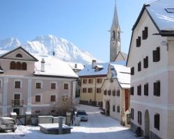 The start of the walk in Sent 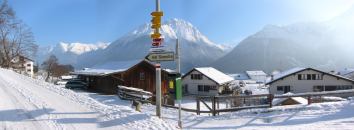 The track rising up from Sent  Along the sunny plateau before the Val Sinestra 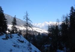 From the shady side valley towards Vna 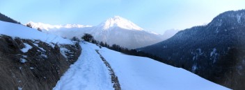 Back along the side of the valley towards the sunshine |
This walk starts from the small and picturesque village of Sent, which can be reached by regular post bus from Scuol in the lower Engadine valley. The walk ends at Vna, from which a post bus links to Ramosch and a second post bus connects back to Scuol.
From Zurich, there are excellent connections to Scuol (less than 3 hours, with one change in Landquart), but it would be a rush to attempt this walk as a day trip. Instead, take advantage of the Engadine hospitality to make a weekend trip, perhaps with another walk (for example, the Scuol valley one) on the other day. The return ticket to Scuol costs CHF 54 with halbtax, and then you just need the bus ticket to Sent (CHF 2) and the bus back from Vna (CHF 4).
For a zoomable, scrollable map of this hike, see this online map using Openstreetmap or Opencyclemap.
You can also download this kmz file val_sinestra.kmz to open it in programs like Google Earth or GpsPrune and then transfer the track to your GPS.
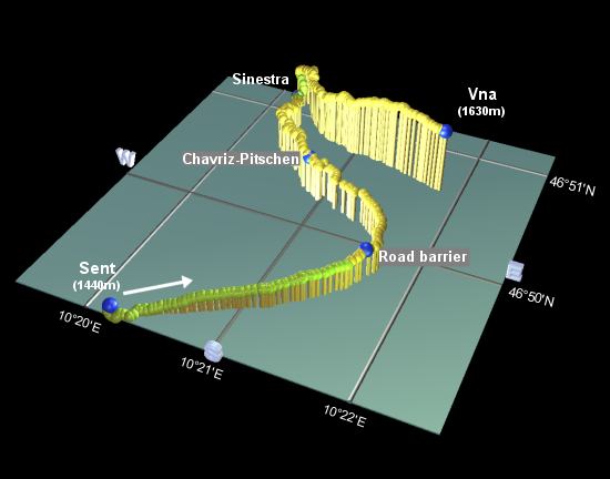
Sent - Sinestra - Chavriz-Pitschen - Vna
 |
From the post bus stop in Sent, continue through the village Northeastwards, away from Scuol, to reach the main road junction. Here, bear slightly left, following the signpost to "Val Sinestra" between the ornate buildings. After a few minutes, as you leave the village, the road splits, with the signposts again leading the way to "Val Sinestra / Via Engiadina".
Follow this broad, level track along the sunny valley, until you reach a road barrier after around an hour. This is only operated at times of avalanche risk, so hopefully it won't impede your walk, but it does mark where the road begins to turn into the Val Sinestra itself. Shortly, you enter the shaded side valley and will be able to see the clustered buildings of Vna perched up on the opposite side to the right.
Although this walk follows a wide, well-maintained road, the road is closed to all except hotel traffic, so you can enjoy the tranquil valley almost all to yourselves, while benefiting from the very easy terrain. Continue on up the left hand side of the valley, reaching the signpost at Chavriz-Pitschen after around 25 minutes.
Continue to follow the road, over a bridge and ignoring a footpath signposted to the Kurhaus, until the road reaches the Berghaus/restaurant at Sinestra, after around 40 minutes. This restaurant (closed throughout January 2003) is the site of the original hotel here in Val Sinestra, until the much larger Kurhaus was built a short distance further up the hillside. Masked by the trees, the imposing Kurhaus only comes into view a little later on this walk.
Take the track down to the right of the Berghaus, cross the main river and then turn left, following the path up to a
signposted path junction. Turn right here, signposted Vna, and climb up the side of the valley. There may be icy patches here,
requiring some care. Heel crampons may also be useful depending on conditions. The path rises gradually as it returns towards
the main Scuol valley, crossing wide open slopes on the way to Vna. This small village, reached after around an hour from Sinestra,
has regular buses down to Ramosch, but check the timetable as some require a (cold) wait before the connection to Scuol.
The following are the coordinates for waypoints along this route, obtained from GPS. They can be used either in another GPS, or along with a map, to provide additional references if necessary.
                           Latitude       Longitude    Altitude(m)
        Sent Post Bus     N 46°49'01.9    E010°20'12.1    1444
        Road barrier      N 46°49'46.8    E010°21'39.3    1511
        Chavriz-Pitschen  N 46°50'17.9    E010°20'52.2    1543
        Sinestra          N 46°51'01.4    E010°20'15.4    1473
        Vna Post Bus      N 46°50'37.3    E010°21'49.2    1629
There is information about the hotel Val Sinestra at valsinestra.ch, including suggestions for activities in the area (but unfortunately not whether the berghaus or kurhaus are currently open). Also there is sent-online.ch for information on Sent, scuol.ch for more on Scuol, and nationalpark.ch for the nearby Swiss national park.
For skiing or snowboarding here, including the "dream run" down to Sent, see Snowboarding in Scuol.