
Hike time: | 4.5 to 5 hours |
Approx dist: | 15 km |
Start: | Schwägalp Passhöhe |
Finish: | Ennetbühl Dorf |
Season: | Most of year |
Profile: | from 1280m up to 1520m and down to 890m |
Rating: | medium, with some exposed narrow paths and steep drops, various scattered rootiness |
Greetings: | "Grüezi" |
This hike starts off close to the imposing wall of Säntis but instead of climbing it, heads westwards with recurring views of the Alpstein massif. The name of the hike comes from the Ofenloch, or "oven hole", a remarkable rock feature in the deeply-carved canyon of the Necker river. This whole gorge landscape is unexpected and very well-hidden, providing a very varied hike.
The views from the Hinterfallenchopf are also spectacular, from Säntis to the lower northern hills, as well as the Churfirstens and the peaks of the Zürcher Oberland.
Most of the trails are clear, if susceptible to slippy mud, but the section around the gorge and past the Ofenloch is narrow and requires some care. Due to the loose stones, the path has been partly washed away in places so steady footwork is also required.
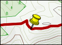
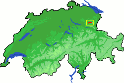 Location of the hike in northeast Switzerland 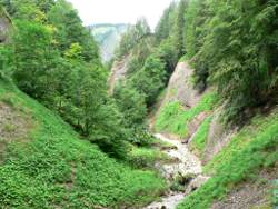 Gorge scenery along the way 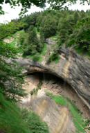 The "pizza oven" in the canyon wall 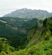 View from Hinterfallenchopf to Säntis |
The start of this walk is Schwägalp Passhöhe, the bus stop one before Schwägalp itself where the cable car goes up to Säntis. At Passhöhe there's a restaurant but not much else. Buses run here from Urnäsch although not very frequently.
From the end of the walk at Ennetbühl, there are hourly buses back to Schwägalp Passhöhe or in the other direction to Nesslau / Neu St Johann.
For a zoomable, scrollable map of this hike, see this online map using Openstreetmap or Opencyclemap.
You can also download this kmz file ofenloch.kmz (4 kb) to open it in programs like Google Earth or GpsPrune and then transfer the track to your GPS.
Schwägalp Passhöhe - Chräzerenpass - Alp Horn - Neuwald - Hinterfallenchopf - Hübschholz - Chlosteralp - Ennetbühl
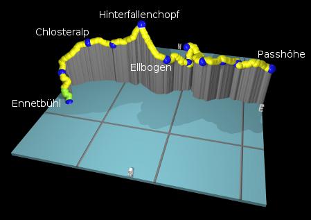 |
From the bus stop at Passhöhe, head away from Säntis past the Gasthaus and at the road junction take the footpath signposted for Chräzerenpass. This path leads through a fertile, open forest which is maintained as a nature reserve. Sometimes muddy, sometimes rooty, and sometimes crossing wooden walkways over the soft ground, the path emerges onto a paved road at Chräzerenpass.
Turn right here along the quiet road, and follow it as far as Chräzerenwald. Then turn left, still along a road and still signposted Hinterfallenchopf (or kopf). As you continue to Alp Horn, you reach an open pasture area with a small farm, and shortly after that a track junction. Here is where we take a detour from the direct route, off to the right to explore the gorge.
Following the signs towards Neuwald and Spicher, the track becomes a path and then suddenly you enter a world of cliffs, gorges, narrow bridges and gushing water, extremely well-hidden from the soft pasture scenery so close by. These cliffs are obviously made of crumbly "Nagelfluh" or conglomerate, the same stuff which nearby Speer is made of. This is why the water was able to cut such dramatic scenery and also why the path needs a cable handrail for the bits where it has crumbled away.
The path doubles back to the left underneath the cliff and passes a small waterfall as it negotiates its way through the gorge. It then surprisingly emerges from the gorge, just as suddenly as it entered, and becomes a grassy and muddy track to Neuwald. Turn left here down the steep grassy path, signposted for "Ofenloch" and for the first time marked with red and white signs.
The path drops back into more rocky terrain, before bringing you suddenly high above a waterfall, with surprisingly steep canyon walls below. Around a corner and a massive oval opening in the cliff wall comes into view, presumably the "oven hole" giving the walk its name. It's said to resemble a pizza oven, which it kind of does superficially, but they would be pretty huge pizzas baking in there if it were. It's on the other side of the spectacular gorge though so exploring it from here is out of the question.
Follow the path back upwards to meet a track, where you turn right towards Ellbogen. Further peaks of the Alpstein massif decorate the views ahead and to the left. At Ellbogen turn right and take the track zigzagging its way up to Hinterfallenchopf. This steep climb has its reward though with a spectacular panorama. This takes in not just the Toggenburger hills ahead but also the flatlands to the east and a great view of Säntis looming over the wooded gorge.
From the peak, follow the path down the other side to meet a track, and past another farm to Hübschholz. From here, both ways are signposted Ennetbühl (our final destination), but we take the right-hand route towards Chlosteralp. The path shortly becomes a track and we get a leisurely look at the Alpstein to our left and the Toggenburg hills ahead. Shortly after Chlosteralp the Churfirstens sweep majestically into view from behind the nearby peaks.
From here it's all downhill, with a panoramic path leading into residential roads and into the centre of Ennetbühl. Once you hit the main road, the bus stop "Ennetbühl Dorf" is just a few steps round to the right. The buses only run once per hour though so either check out the times in advance, or pass the time in one of the Gasthäuser in the village.
The following are the coordinates for waypoints along this route, obtained from GPS. They can be used either in another GPS, or along with a map, to provide additional references if necessary.
                           Latitude       Longitude    Altitude(m)
       Passhöhe           N 47°15'20.5    E009°18'34.1    1279
       Chräzerenpass      N 47°15'25.3    E009°17'36.8    1269
       Chräzerenwald      N 47°15'19.7    E009°17'10.4    1300
       Alp Horn           N 47°15'12.8    E009°16'36.5    1300
       Neuwald            N 47°15'39.5    E009°16'02.0    1318
       Ofenloch           N 47°15'29.2    E009°16'08.0 (approx)
       Ellbogen           N 47°15'13.4    E009°15'30.7    1270
       Hinterfallenchopf  N 47°15'26.9    E009°14'39.7    1532
       Hübschholz         N 47°15'24.5    E009°13'42.9    1318
       Chlosteralp        N 47°15'19.0    E009°12'54.8    1326
       Brüggli            N 47°14'47.3    E009°12'13.9    1106
       Ennetbühl          N 47°14'26.1    E009°12'36.5     891
This hike is described briefly (in english) at wanderland.ch. One alternative route described elsewhere misses out the Hinterfallenchopf, but instead bears further north over further peaks, looping back to finish at Urnäsch.