
Hike time: | 4.5 hours |
Start: | post bus Romoos |
Finish: | post bus Fankhaus |
Season: | Summer |
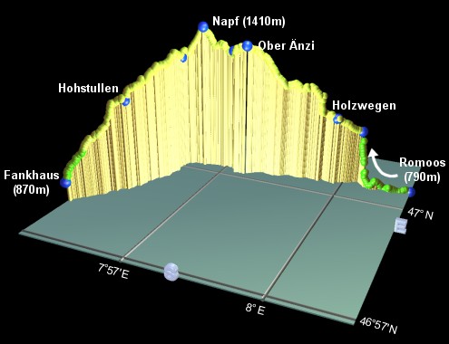
Profile: | from 790m up to 1410m, then back down to 870m |
Rating: | fairly long, easy-medium up but tricky down |
The Napf is a very broad, 1400m hump, ideally situated for panoramic views of the surrounding peaks. Range after range of hills recede magically into the mist, while the Napf itself provides trouble-free walking. This walk covers quite a distance, up and over the summit, but apart from a little navigational care being required, it is not too difficult.
The start of the walk is Romoos, which is reached by post bus from Wolhusen (which is a train ride West from Luzern). From the end of the hike at Fankhaus (listed on the SBB website as "Fankhaus (Trub)"), there are hourly post buses to Langnau, from where there are train connections to both Luzern and Bern.
To make this trip from Zurich, take the train to Luzern (50 mins), the train to Wolhusen (30 mins), and then the post bus to Romoos (20 mins). On the way back, take the post bus from Fankhaus to Langnau (25 mins), and then depending on the exact connections, return from Langnau either via Luzern, or via Bern. The Luzern way is cheaper and often quicker. Total cost (with halbtax): CHF 38
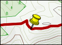
For a zoomable, scrollable map of this hike, see this online map using Openstreetmap or Opencyclemap.
You can also download this kmz file napf.kmz to open it in programs like Google Earth or GpsPrune and then transfer the track to your GPS.
Romoos - Holzwegen - Ober Änzi - Napf - Grüebli - Hohstullen - Fankhaus
 |
From the post bus stop, follow the footpath signs for "Napf" through the small village of Romoos, and branch off to the right down a smaller road at the fork. A short stroll down here brings you to a timber yard at a junction, where you follow the signs to the right up another narrow lane. A signpost points left up a steep, rooty diversion which is fairly superfluous as it just rejoins the pleasant lane again shortly after. At the bridge, there are two signposts to the Napf - here you should continue to follow the road, over the bridge and shortly afterwards follow the signpost left up a steep path.
Keep following the signs up the tight switchbacks - some of these are difficult to see. When your path meets a level grassy track, go up to the right to a bench and then onwards up the narrow path marked with a yellow diamond. Pass to the right of the farm buildings, still with a sharp lookout for the yellow diamonds and arrows. When you meet another level track by a bent signpost, look up to the left for a painted yellow diamond on a tree, marking the faint diagonal path across the field. The signs eventually lead up to Grämsen after around 50 minutes, where you turn left on a broad track running along the ridge. There are plenty of views to be had here, to the West and North.
This easy track leads gently on to Holzwegen after around 10 minutes, with its cluster of buildings and tiny church. The signs lead on the quiet, level paved road, before taking a footpath up to the right. There are more views South as the route goes along the ridge, still signposted either "Napf" or "Wanderweg", past a wooden crucifix and a small house to reach Ober Änzi after around 30-40 minutes.
The climb continues for another 35 minutes or so up a steep stony track to the summit of the Napf at 1410m, on which there is a restaurant and some spectacular views. The Autumn mist can really lend an atmosphere to the ripples of mountain ridges extending far into the massive distance. Panorama boards tell the whole story from the Jura through central Switzerland and round to the Berner Oberland.
There are (at least) two options for the descent, there is a signed footpath down to Mettlenalp, from which a paved road leads for quite a way along to Fankhaus, which is probably easier than the occasionally difficult way described here through Grüebli:
From the Eastern end of the restaurant on the summit, take the signposted track to Fankhaus, leading Eastwards down a faint path. After around 15 minutes you reach Grüebli. Take the left-hand track here, signposted as the shorter route to Fankhaus bus stop, and follow the telegraph poles along the top of a narrow spur. Drop (awkwardly) through the trees on the steep rooty path, to reach Hohstullen after around 35 minutes.
The sign to Fankhaus here points diagonally across the field of cows, although it requires a fence-hop to join the recently-dug track heading to the right. Another tricky steep trail brings you out to an idyllic house with wary horses, and another desecent brings you out to a bench in the open after around half an hour. Here the tranquil scenery shows all the carpeted folds of the Napf hillsides.
From here, it's a straightforward trail straight on down to the farm, and left to meet the main road. The bus stop is just a short distance to the right, around 10 minutes from the bench. Buses run approximately hourly to Langnau.
The following are the coordinates for waypoints along this route, obtained from GPS. They can be used either in another GPS, or along with a map, to provide additional references if necessary.
                           Latitude       Longitude    Altitude(m)
Romoos post bus           N 47°00.671'   E008°01.657'     792
Grämsen                   N 47°00.713'   E008°00.343'    1020
Holzwegen                 N 47°00.483'   E007°59.784'    1080
Ober Änzi                 N 47°00.176'   E007°57.599'    1353
Stachelegg                N 47°00.334'   E007°57.153'    1315
Napf                      N 47°00.210'   E007°56.431'    1408
Grüebli                   N 47°00.086'   E007°55.934'    1280
Hohstüllen                N 46°58.864'   E007°55.410'    1170
Fankhaus post bus         N 46°58.015'   E007°54.496'     876
There's more suggestions and small photos at the gruxa.ch napf page.
Also, don't forget to pick up the free leaflet from the Romoos post bus which has a diagram of the area and more suggested walks.