
Hike time: | 3 hours |
Approx dist: | 10 km |
Start: | Disentis station |
Finish: | Sedrun station |
Season: | Winter |
Profile: | from 1130m up to 1450m |
Rating: | medium length, fairly easy Winter walk |
Greetings: | "Bun di", "Allegra" |
Hike time: | 7.5 hours without cable car |
Approx Dist: | 19 km |
Start/Finish: | Disentis station |
Season: | Summer |
Profile: | from 1130m up to 2280m and back |
Rating: | medium difficulty but fair amount of climbing |
Greetings: | "Bun di", "Allegra" |
Disentis is a fair-sized town in the Romansch-speaking region between Chur and Andermatt. In the Winter this is a skiing area up to 2850m, with a low-level Winterwanderweg to Sedrun. This is actually part of a much longer footpath, the Senda Sursilvana, which runs all the way from Chur to Oberalppass, around 100km. On this short stretch, it passes gently along the valley keeping fairly close to the train line as it goes. The scenery is rural, and provides an interesting excursion to small villages in the varied Romansch region.
In Summer, obviously the Senda Sursilvana is still available, but we can take the opportunity to explore higher up for some alternative valley views. Here the suggested route climbs up to Caischavedra and loops round past two high lakes before dropping back down to the valley floor.
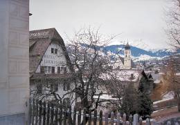 Picturesque town centre of Disentis 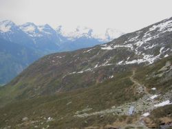 Path across the barren hillside, near Lag Serein  Wide-ranging views down to the Disentis valley 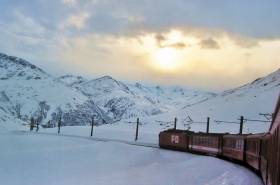 Train from Sedrun up towards the Oberalppass |
Disentis lies on the main rail line between Chur and Andermatt, with regular trains both ways. For the Winter walk, the route ends at Sedrun station, which is also on this same line.
From Zürich, there's a neat (if long) round-trip possible, in the quest to avoid retracing train journeys. Firstly take the train to Chur (1h20) and from there to Disentis (1h15) to start the walk; then from Sedrun continue in the same direction to Andermatt, and from there back to Zurich via Göschenen and Arth-Goldau (total about 3h). This gives a good tour of the area, with great scenery including the "Rhine Gorge" where the Rhein river has cut a dramatic channel through the crumbling debris of an old landslide. From Sedrun to Andermatt is another scenic section, where the train climbs up to the wild and Wintry Oberalppass, before dropping down into Andermatt. Note the last train times from Sedrun however, as the trains to Andermatt finish earlier than the ones back to Chur.
Depending on the exact route you take, you may find a Tageskarte (CHF 52 from the ticket machines) worthwhile, giving both a small reduction and greater convenience and flexibility. However beware of supplements between Disentis and Göschenen, which add CHF10 on Fridays, Saturdays and Sundays.
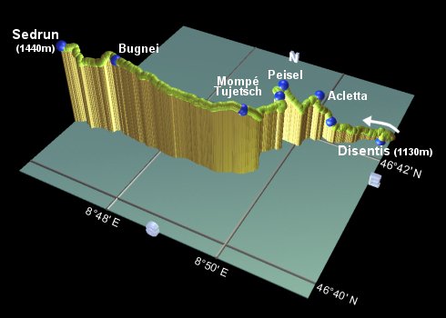
Disentis - Acletta - Peisel - Mompé Tujetsch - Bugnei - Sedrun
 |
From the station at Disentis, the Senda Sursilvana signposts lead you out along the main road of Disentis. However, a more interesting route goes up to the Kloster, or monastery, which you can see (and probably hear) from the station. Yellow diamond marks lead up stone steps to reach the imposing building after a few minutes.
Turn left at the left-hand end of the Kloster, and follow the level path towards Acletta / Sa. Catrina, looking out over the picturesque town below. Fork right after 100 yards at a signpost for an alleged Planetenweg, and continue until you reach a small stream. Here you join the Senda Sursilvana again, where the signposts lead up alongside the stream, to reach the cable car station at Sa. Catrina after around 20 minutes.
The Senda Sursilvana signposts then lead up underneath the cables, climbing round to the left to reach Acletta after another 10 minutes.
Follow the signs to "Peisel / Segnas", and when the road ends in a small turning circle, follow the path ahead to meet a wider track, and turn right to Glaretsch. The path then climbs slightly to reach Peisel after around 20 minutes.
Another 10 minutes brings you to the village of Segnas (1330m), through which the path continues, with various detours, signposted "Sedrun".
Passing several picnic benches, the track starts to rise gently and then more steeply, (with occasional icy patches) to eventually reach the church at Mompé Tujetsch (1400m) after about half an hour. Here the snow-capped peaks make a great backdrop for the characterful village houses.
Continue through pine trees on the gently rising track, to meet the train track after about 20 minutes. The views open out once more across the valley, as the route continues and eventually crosses the train tracks at Bugnei after another half an hour.
Cross the impressive viaduct, and then follow the signs down to the main road. Turn right and wander through the main street of Sedrun, until a sign leads you to the right, back towards the train tracks and Staziun Sedrun (1440m) after another 25 minutes.
Disentis - Acletta - Caischavedra - Lag Serein - Lag Crest Ault - Plaun Grond - Clavaniev - Disentis
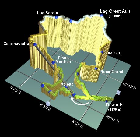 |
As this hike goes up to almost 2300m, snow can present problems early in the walking season. In late May there was still quite a lot of snow covering the path, and some of the stream-crossings were a bit tricky. Best to leave this one until July for better conditions.
This longer hike climbs from Disentis up to the upper cable car station of Caischavedra, so obviously the cable car may be taken to eliminate a good 600m+ of climb. In any case, this Summer walk starts off the same way as the Winter one above, at least as far as the lower cable car station of Sa. Catrina. Hardy hikers can then opt for some extra leg-work, while the rest can part gladly with their CHF 14 and save a couple of hours.
For the hard way up, continue to follow the Senda Sursilvana as described above, as far as Peisel. Here, turn right signposted Caischavedra, winding up a road back under the cables to Plaun Menisch. A steep cycle track leaves the road here, signposted Caischavedra, and pulls sharply up the hillside. eventually reaching the top cable car station at Caischavedra after around 1h45 to 2h from Sa. Catrina.
From Caischavedra, itself a good lookout point at 1860m, follow the signposts towards Lag Serein, leading uphill behind the row of flags. As this narrow track swings round to the left, take the unmarked path to the right, leading across the hillside to the left of the solar panels. Climb up through the rocky scrub (with perhaps the occasional boggy bit) and around the crest of the ridge. Here you enter a large, round, bowl of a valley, and so the path sweeps round in a right-handed curve as it steadily climbs. It crosses several streams (some of them quite big), although it looks like some of these would be bridged in the high season (but not in late May). The lake Lag Serein is rather small, and well hidden until you reach it, around 1h15 from Caischavedra. The signpost is just beyond the lake by a small hut.
The path splits at Lag Serein, so make sure you go upwards here towards Plaun Tir and Lag Crest Ault, not downhill following the stream. Cross the stream using the bridge, climb up to the ridge and enter the second, large, round bowl valley. There are many white-red-white markings here to guide you. The path continues along a rounded ridgetop to the barely noticeable lake Lag Crest Ault after around 1h20.
Again, the signpost for the lake can be found just beyond the lake itself, and leads the way on towards Alp Run and Plaun Grond. The white-red-white markings again are frequent, if occasionally a little hard to spot, taking you downhill to Truaisch in around 50 minutes.
Cross the road and continue on the path signposted Plaun Grond through the forest. The narrow path descends fairly steeply with some rootiness, and crosses the road a couple more times (watch out for squirrels!) before emerging at Plaun Grond after around half an hour.
From here, two signposts lead to Disentis, we turn right to take the slightly less direct route via Clavaniev. Initially taking the road, this takes a couple of switchbacks before a path leaves to the right. This crosses the stream and then descends alongside it, with yellow diamond marks leading the way into the cluster of buildings at Clavaniev in around 40 minutes.
Turn right in Clavaniev, downhill signposted Disentis, and drop down a track to reach the edge of Disentis. Soon you will meet and cross your outbound route, where the signposts for Staziun lead you back to the station, around 20 minutes from Clavaniev.
                       Latitude       Longitude    Altitude(m)
Disentis Stn          N 46°42'19.1   E008°51'19.4     1130
Sa Catrina            N 46°42'02.7   E008°50'29.4     1215
Acletta               N 46°42'03.4   E008°50'12.1     1300
Glaretsch             N 46°41'47.8   E008°49'55.3     1300
Peisel                N 46°41'48.8   E008°49'39.8     1350
Segnas                N 46°41'41.0   E008°49'42.1     1331
Mompé Tujetsch        N 46°41'01.4   E008°49'29.8     1390
Bugnei                N 46°40'56.8   E008°47'11.2     1434
Sedrun station        N 46°40'51.1   E008°46'10.0     1441

Plaun Menisch         N 46°42'15.8   E008°49'34.0     1598
Caischavedra          N 46°42'16.3   E008°48'54.7     1860
Lag Serein            N 46°43'08.9   E008°48'48.5     2072
Plaun Tir             N 46°43'06.5   E008°49'22.3     2145
Lag Crest Ault        N 46°43'32.7   E008°50'05.9     2278
Truaisch              N 46°42'53.6   E008°50'37.8     1830
Plaun Grond           N 46°42'38.1   E008°50'41.0     1590
Crap Furau            N 46°42'27.2   E008°50'13.8     1375
Clavaniev             N 46°42'19.6   E008°50'32.8     1288
General information on the Disentis area, for skiing in the Winter and hiking in the Summer, is in German at disentis3000.ch, with suggested hikes under "Sommer" and then "Wanderer".
There is information about the Disentis and Sedrun area, and a (very) rough outline of the Senda Sursilvana (under Wandern - Senda Sursilvana) at disentis-sedrun.ch, and some good plans of the parts of the walks near Disentis (as far as Peisel) at disentis.ch (under Gemeinde Disentis - Ortsplan).