
Hike time: | 5.5 to 6 hours |
Approx dist: | 18 km |
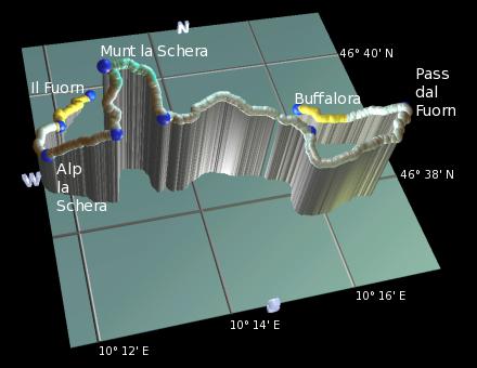
Start: | Il Fuorn |
Finish: | Buffalora |
Season: | Summer / Autumn |
Profile: | from 1780m up to 2580m and down to 1970m |
Rating: | medium, just a few narrow rocky bits |
Greetings: | "Allegra", "Grüezi" |
This medium-length day walk explores one of the peaks in the Swiss National Park called Munt la Schera, just east of Zernez. It's in the Romansch-speaking area of Graubünden, very close to the Italian border near Livigno, but the pass labelled here as Pass dal Fuorn is also known by German-speakers as Ofenpass. Quite why this pass is named after an oven remains a mystery.
The national park is strictly protected and therefore a lot of the landscape here is wild and surprisngly bleak. Leaving the marked footpath is strongly discouraged, which has the benefit that the markings and signpostings are immaculate, and navigation is problem-free.
After climbing steadily around to the southern side of Munt la Schera, with views out over the dammed lake to the south, this route takes a detour up to the summit itself for the panorama, before rejoining the eastward path down towards Buffalora. It then continues in a wider loop round via the pass to follow the valley down to Buffalora, although there is a more direct option as well.
 View across the rockslide during the ascent to Alp la Schera 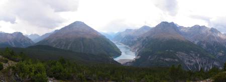 Panorama from near Munt la Schera summit towards Livigno 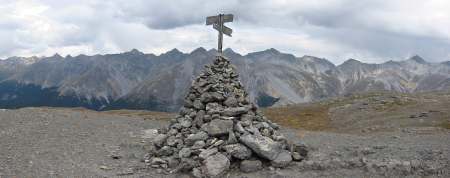 Summit of Munt la Schera 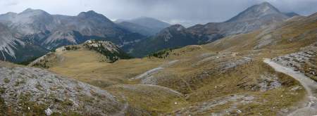 Bleak landscapes on descent towards Alp Buffalora |
The access point for this walk is Il Fuorn, a short bus ride east of Zernez in the Swiss national park. For the return journey, the same buses travel back from the pass (also known as Ofenpass, or Süsom Givé) through Buffalora and Il Fuorn back to Zernez. There's also plenty of car parking available.
From Zürich, this makes a rather long day trip, taking around 3 hours to get to Il Fuorn, but closer to 4 hours to get back again due to more frequent stops on the trains. You need to change at Landquart to get the train through the Vereina tunnel to Sagliains in the Unterengadin, and then change there to get a local train to Zernez for the connecting bus. A Tageskarte for the whole trip costs CHF 56 if you have a halbtax card.
For a zoomable, scrollable map of this hike, see this online map using Openstreetmap or Opencyclemap.
You can also download this kmz file munt_la_schera.kmz to open it in programs like Google Earth or GpsPrune and then transfer the track to your GPS.
Il Fuorn - Alp la Schera - Munt la Schera - Pass dal Fuorn (Ofenpass) - Buffalora
 |
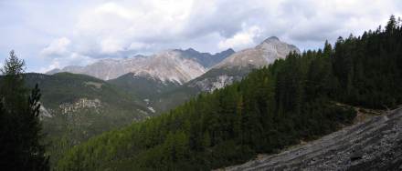
From the bus stop at Il Fuorn, follow the signposts towards Alp la Schera. These lead back alongside the road towards Zernez but only for 300m, before cutting left up the hillside. Passing up through the trees, the gradient is moderate but constant, climbing steadily to the southwest. After around 200m of ascent the path crosses a large rockslide, threading a narrow path across the turmoil.
Continuing to climb, but curving slowly round to the south, the path reaches the treeline and the views open out accordingly. The dammed Lago di Livigno appears as you round the corner, seeming just a stone throw's away in Italy, lying in a hook shape in the valley below. Shortly you reach Alp la Schera, a tempting picnic spot with benches. Here, unusually, you're actually allowed to leave the path to eat your sandwiches, albeit within a carefully marked-out area.
After leaving the 'Rastplatz', the path continues to climb and continues to curve leftwards, passing round to the southern side of Munt la Schera. Accompanied by the wide views across to Italy, you shortly reach a signpost (given here as 'Signpost1'), where the detour to the summit begins. Those whose legs are already aching from the ascent so far could opt to miss the peak and continue straight ahead here to Signpost2.
For the final push to the summit of Munt la Schera, take the signposted sharp left heading northwards and uphill. The terrain is now quite bare and rather bleak as the path zigzags up the slope, with more of the same Lago di Livigno views. The rounded summit is even bleaker, a dry and grey plateau with views in all directions. The small cairn marking the summit is just to the left of the main path, with a forlorn-looking wooden cross.
To continue the hike, take the obvious eastward path dropping gradually across the wild scenery, curving round to the right to drop down to Signpost2 back on the original path. Here turn left and follow the path traversing the hillside eastwards towards Alp Buffalora.
Apart from a small rise, the path drops gradually over the scrubby, wild landscape, looking nothing like any Swiss calendar you've ever seen. Shortly you round the corner and glimpse the Il Fuorn valley once again. Somewhere down there is Buffalora, and there is a direct path dropping down through Alp Buffalora, but we're going to take a slightly longer way round. So instead of turning left at the signpost (Signpost3) towards Buffalora, we'll turn right signposted for Pass dal Fuorn in order to loop around.
The track heads south before curving round to the left, and at the next signpost turns left towards the pass. It then climbs a little into rockier, slightly trickier terrain, taking a narrow path through a miniature gorge. Crumbling, erosion-sculpted rocks loom overhead as the path drops steeply in zigzags, before flattening out and passing a radio mast on its way down to the Pass dal Fuorn.
On the pass you can find a restaurant, souvenir stands and a bus stop, and a massive car park. You could get the bus back to Zernez from here, but the walk down the valley to Buffalora is pleasant (once it gets away from the road) and only a gentle 30 to 40 minutes. The restaurant at Buffalora is perfectly situated at the end of the walk, right next to the bus stop, and provides a very friendly welcome. And Apfeltaschen.
The following are the coordinates for waypoints along this route, obtained from GPS. They can be used either in another GPS, or along with a map, to provide additional references if necessary.
                           Latitude       Longitude    Altitude(m)
       Il Fuorn           N 46°39'51.5    E010°12'38.0    1794
       Rockslide          N 46°39'07.5    E010°11'58.7    1984
       Alp la Schera      N 46°38'35.0    E010°11'42.8    2091
       Signpost1          N 46°38'19.0    E010°12'41.4    2338
       Munt la Schera     N 46°38'42.6    E010°12'38.4    2587
       Signpost2          N 46°38'21.2    E010°13'23.5    2380
       Signpost3          N 46°38'10.6    E010°15'41.2    2206
       Pass dal Fuorn     N 46°38'23.4    E010°17'30.7    2149
       Buffalora          N 46°38'53.5    E010°16'00.5    1968
A rough map of the area can be found at map.search.ch. The shorter variant via Alp Buffalora down to Buffalora is described (in German) as the second day of a two-day hike at wandersite.ch and a second, even shorter variant at about.ch. There's also more information about the park at nationalpark.ch.